Difference between revisions of "2013-02-06 42 -87"
imported>RocketMac (→Expedition) |
imported>RocketMac (→Photos) |
||
| Line 27: | Line 27: | ||
== Photos == | == Photos == | ||
| − | |||
| − | |||
| − | |||
<gallery perrow="5"> | <gallery perrow="5"> | ||
| + | Image:RocketMac 2013-02-06 06.jpg | The Hashpoint | ||
| + | Image:RocketMac 2013-02-06 05.jpg | Stupid Grin | ||
| + | Image:RocketMac 2013-02-06 02.jpg | The road ahead | ||
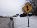
| + | Image:RocketMac 2013-02-06 03.jpg | 60th St Bridge | ||
| + | Image:RocketMac 2013-02-06 01.jpg | Map | ||
| + | Image:RocketMac 2013-02-06 07.jpg | GPS | ||
</gallery> | </gallery> | ||
Revision as of 06:23, 14 February 2013
| Wed 6 Feb 2013 in 42,-87: 42.9621627, -87.9879704 geohashing.info google osm bing/os kml crox |
Location
The side of 894E just past the 60th St. bridge.
Participants
Plans
I have the day off work, so I was glad to see the day's hash point was someplace I could reach and nearby.
Expedition
A pretty straight-forward trip. Last year I bought a Looxcie Camera and thought this would be a good use for it. I started my GPS tracklog and was on my way.
The hashpoint was on the south side of the highway and just east of the 60th street bridge. I wanted to earn the [[Speed_racer_achievement|Speed Racer Achievement] so I kept my speed up as far as I could then flipped on my signal and moved to the shoulder to begin braking.
Once parked, I got out and took some pictures. Nothing particularly stunning. Just a dreary roadside on a February day.
Tracklog
My GPS tracklog is available in GPX and KMZ formats.
Photos
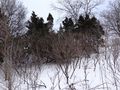
The Hashpoint
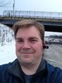
Stupid Grin
The road ahead
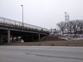
60th St Bridge
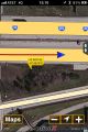
Map
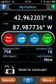
GPS


Video
I took this video with my Looxie camera.
Achievements
RocketMac earned the Land geohash achievement
|
