Difference between revisions of "2013-07-07 52 9"
From Geohashing
imported>GeorgDerReisende (Created page with "{{subst:Expedition |lat = 52 |lon = 9 |date = 2013-07-07 }}") |
imported>GeorgDerReisende |
||
| Line 1: | Line 1: | ||
| − | |||
| − | |||
| − | |||
| − | |||
| − | |||
| − | |||
| − | |||
| − | |||
| − | |||
{{meetup graticule | {{meetup graticule | ||
| lat=52 | | lat=52 | ||
| Line 18: | Line 9: | ||
__NOTOC__ | __NOTOC__ | ||
== Location == | == Location == | ||
| − | + | The hash is in the forest of the ''Saupark'' near Springe. Compared with the meetup of yesterday ([[2013-07-06 52 9]]), when the hash lied in a big river, today the meetup seemed to fall into a very small brook. But it is only nearby. | |
== Participants == | == Participants == | ||
| − | + | [[User:GeorgDerReisende|GeorgDerReisende]] | |
| − | |||
== Plans == | == Plans == | ||
| − | + | The plan was to spend the night nearby, visit the hash and then to hitchhike home. | |
== Expedition == | == Expedition == | ||
| − | + | Like the plan. [[User:GeorgDerReisende|GeorgDerReisende]] visited the hash and then he went home by hitchhiking, along Eldagsen, Hildesheim and the service station Hildesheimer Börde. | |
| + | |||
| + | Question: can I take the hitchhiking achievement, because I went home by hitchhiking? | ||
== Tracklog == | == Tracklog == | ||
| Line 34: | Line 26: | ||
== Photos == | == Photos == | ||
| − | |||
| − | |||
| − | |||
<gallery perrow="5"> | <gallery perrow="5"> | ||
| + | Image:2013-07-07 52 9 GeorgDerReisende 6499.jpg | the gate seems closed | ||
| + | Image:2013-07-07 52 9 GeorgDerReisende 6501.jpg | but the small gate is open | ||
| + | Image:2013-07-07 52 9 GeorgDerReisende 6500.jpg | hints for the use | ||
| + | Image:2013-07-07 52 9 GeorgDerReisende 6507.jpg | wildlife preserve area | ||
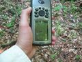
| + | Image:2013-07-07 52 9 GeorgDerReisende 6508.jpg | sometimes the gps is walking alone | ||
| + | Image:2013-07-07 52 9 GeorgDerReisende 6509.jpg | the brook is nearby the hash | ||
| + | Image:2013-07-07 52 9 GeorgDerReisende 6516.jpg | the proof | ||
</gallery> | </gallery> | ||
== Achievements == | == Achievements == | ||
{{#vardefine:ribbonwidth|800px}} | {{#vardefine:ribbonwidth|800px}} | ||
| − | |||
| + | {{land geohash | ||
| − | + | | latitude = 52 | |
| − | + | | longitude = 9 | |
| − | + | | date = 2013-07-07 | |
| + | | name = GeorgDerReisende | ||
| − | + | }} | |
| − | |||
| − | |||
| − | |||
| − | |||
[[Category:Expeditions]] | [[Category:Expeditions]] | ||
| − | |||
[[Category:Expeditions with photos]] | [[Category:Expeditions with photos]] | ||
| − | |||
| − | |||
| − | |||
| − | |||
[[Category:Coordinates reached]] | [[Category:Coordinates reached]] | ||
| − | |||
| − | |||
| − | |||
| − | |||
| − | |||
| − | |||
| − | |||
| − | |||
| − | |||
| − | |||
| − | |||
| − | |||
| − | |||
| − | |||
| − | |||
| − | |||
| − | |||
| − | |||
Revision as of 22:18, 9 July 2013
| Sun 7 Jul 2013 in 52,9: 52.1754668, 9.5963789 geohashing.info google osm bing/os kml crox |
Location
The hash is in the forest of the Saupark near Springe. Compared with the meetup of yesterday (2013-07-06 52 9), when the hash lied in a big river, today the meetup seemed to fall into a very small brook. But it is only nearby.
Participants
Plans
The plan was to spend the night nearby, visit the hash and then to hitchhike home.
Expedition
Like the plan. GeorgDerReisende visited the hash and then he went home by hitchhiking, along Eldagsen, Hildesheim and the service station Hildesheimer Börde.
Question: can I take the hitchhiking achievement, because I went home by hitchhiking?
Tracklog
Photos
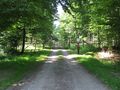
the gate seems closed
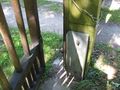
but the small gate is open
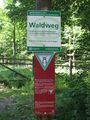
hints for the use
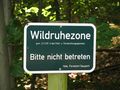
wildlife preserve area
sometimes the gps is walking alone
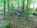
the brook is nearby the hash
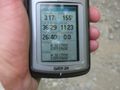
the proof


Achievements
GeorgDerReisende earned the Land geohash achievement
|