Difference between revisions of "2013-07-17 33 -116"
From Geohashing
imported>LucasBrown ([retro picture] Local map near the hashpoint. Screenshot captured at the closest vehicular approach.) |
imported>LucasBrown ([retro picture] Regional map near the hashpoint) |
||
| Line 42: | Line 42: | ||
Image:2013-07-17_33_-116_02-16-43-458.jpg | Local map near the hashpoint. Screenshot captured at the closest vehicular approach. | Image:2013-07-17_33_-116_02-16-43-458.jpg | Local map near the hashpoint. Screenshot captured at the closest vehicular approach. | ||
| + | |||
| + | Image:2013-07-17_33_-116_02-17-25-440.jpg | Regional map near the hashpoint | ||
</gallery> | </gallery> | ||
Revision as of 09:17, 18 July 2013
| Wed 17 Jul 2013 in 33,-116: 33.1080719, -116.8214577 geohashing.info google osm bing/os kml crox |
Location
Participants
Plans
Expedition
Tracklog
Photos
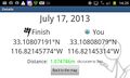
Geohash Droid details page at the hashpoint
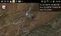
Local map near the hashpoint. Screenshot captured at the closest vehicular approach.
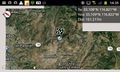
Regional map near the hashpoint


Achievements