Difference between revisions of "2013-08-23 43 -116"
imported>Eldin (initial report) |
imported>Eldin (add pictures.) |
||
| Line 1: | Line 1: | ||
| − | |||
| − | |||
| − | |||
| − | |||
| − | |||
| − | |||
| − | |||
| − | |||
| − | |||
| − | |||
{{meetup graticule | {{meetup graticule | ||
| lat=43 | | lat=43 | ||
| Line 15: | Line 5: | ||
}} | }} | ||
| − | |||
__NOTOC__ | __NOTOC__ | ||
| Line 23: | Line 12: | ||
== Participants == | == Participants == | ||
[[User:Eldin|Eldin]] | [[User:Eldin|Eldin]] | ||
| − | |||
| − | |||
| − | |||
== Expedition == | == Expedition == | ||
After work, I drove out to the location of the hash. It was somewhat questionable whether or not I'd be able to reach it, as about half of the fields in the area are fenced or still have crops growing. But fortunately, this one was bare and unfenced. Unfortunately, it was muddy. I found a spot nearby to park my car, and trudged about 500ft through the mud to reach the coordinates. Once there I took some pictures, and headed back. Not a particularly interesting or eventful hash, but I'm glad it was reachable as it's been a couple weeks since I was last able to get out hashing. | After work, I drove out to the location of the hash. It was somewhat questionable whether or not I'd be able to reach it, as about half of the fields in the area are fenced or still have crops growing. But fortunately, this one was bare and unfenced. Unfortunately, it was muddy. I found a spot nearby to park my car, and trudged about 500ft through the mud to reach the coordinates. Once there I took some pictures, and headed back. Not a particularly interesting or eventful hash, but I'm glad it was reachable as it's been a couple weeks since I was last able to get out hashing. | ||
| − | |||
| − | |||
| − | |||
== Photos == | == Photos == | ||
| − | |||
| − | |||
| − | |||
<gallery perrow="5"> | <gallery perrow="5"> | ||
| + | File:2013-08-23 proof.jpg | Proof that I was in the right spot. | ||
| + | File:2013-08-23 grin.jpg | Me, grinning at the spot. | ||
| + | File:2013-08-23 point.jpg | Aproximately the spot. | ||
| + | File:2013-08-23 field.jpg | The field in which the hash was located. | ||
</gallery> | </gallery> | ||
| Line 44: | Line 28: | ||
{{Land geohash|date=2013-08-23|latitude=43|longitude=-116|name=[[User:Eldin|Eldin]]}} | {{Land geohash|date=2013-08-23|latitude=43|longitude=-116|name=[[User:Eldin|Eldin]]}} | ||
| − | |||
| − | |||
| − | |||
| − | |||
| − | |||
| − | |||
| − | |||
| − | |||
| − | |||
| − | |||
[[Category:Expeditions]] | [[Category:Expeditions]] | ||
| − | |||
[[Category:Expeditions with photos]] | [[Category:Expeditions with photos]] | ||
| − | |||
| − | |||
| − | |||
| − | |||
| − | |||
[[Category:Coordinates reached]] | [[Category:Coordinates reached]] | ||
| − | |||
| − | |||
| − | |||
| − | |||
| − | |||
| − | |||
| − | |||
| − | |||
| − | |||
| − | |||
| − | |||
| − | |||
| − | |||
| − | |||
| − | |||
| − | |||
| − | |||
| − | |||
Revision as of 05:46, 29 August 2013
| Fri 23 Aug 2013 in 43,-116: 43.6472529, -116.5722176 geohashing.info google osm bing/os kml crox |
Location
In an empty field at the edge of Nampa
Participants
Expedition
After work, I drove out to the location of the hash. It was somewhat questionable whether or not I'd be able to reach it, as about half of the fields in the area are fenced or still have crops growing. But fortunately, this one was bare and unfenced. Unfortunately, it was muddy. I found a spot nearby to park my car, and trudged about 500ft through the mud to reach the coordinates. Once there I took some pictures, and headed back. Not a particularly interesting or eventful hash, but I'm glad it was reachable as it's been a couple weeks since I was last able to get out hashing.
Photos
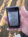
Proof that I was in the right spot.

Me, grinning at the spot.
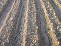
Aproximately the spot.
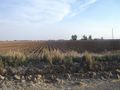
The field in which the hash was located.


Achievements
Eldin earned the Land geohash achievement
|