Difference between revisions of "2014-02-11 52 5"
From Geohashing
imported>JwB m (→Location) |
imported>JwB m |
||
| Line 28: | Line 28: | ||
== Plans == | == Plans == | ||
| − | + | Take a small detour on the route to work and get there at sunrise. This one ought to be easy and therefore suited for me. | |
== Expedition == | == Expedition == | ||
<!-- how it all turned out. your narrative goes here. --> | <!-- how it all turned out. your narrative goes here. --> | ||
| − | |||
| − | |||
== Photos == | == Photos == | ||
<!-- Insert pictures between the gallery tags using the following format: | <!-- Insert pictures between the gallery tags using the following format: | ||
| − | + | ||
--> | --> | ||
<gallery perrow="5"> | <gallery perrow="5"> | ||
| + | Image:GPSe-00008.jpg | marker to show that you're far below sea level; approx 40 m from hash. park car here | ||
| + | </gallery> | ||
| + | |||
| + | <gallery perrow="5"> | ||
| + | Image:Screenshot 2014-02-11-08-14-39.png | walking around to get a low reading on the droid app | ||
| + | </gallery> | ||
| + | |||
| + | <gallery perrow="5"> | ||
| + | Image:20140211 081414.jpg | Me walking around | ||
| + | </gallery> | ||
| + | |||
| + | <gallery perrow="5"> | ||
| + | Image:GPSe-00010.jpg | might as well get onto the road after passing though the hash. Not sure about speed limits off road though | ||
</gallery> | </gallery> | ||
| + | |||
| + | |||
== Achievements == | == Achievements == | ||
Revision as of 08:50, 11 February 2014
| Tue 11 Feb 2014 in 52,5: 52.5562134, 5.7804640 geohashing.info google osm bing/os kml crox |
Location
between the ketelmeerweg and a ditch separating it from a field
Participants
JwB
Plans
Take a small detour on the route to work and get there at sunrise. This one ought to be easy and therefore suited for me.
Expedition
Photos
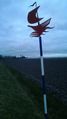
marker to show that you're far below sea level; approx 40 m from hash. park car here


walking around to get a low reading on the droid app


Me walking around

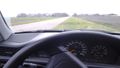
might as well get onto the road after passing though the hash. Not sure about speed limits off road though

Achievements