Difference between revisions of "2015-01-22 52 1"
imported>Sourcerer m ([live picture] [http://www.openstreetmap.org/?lat=52.38950193&lon=1.41258538&zoom=16&layers=B000FTF @52.3895,1.4126]) |
imported>Sourcerer m (→Added New Expedition) |
||
| Line 1: | Line 1: | ||
| − | |||
| − | |||
| − | |||
| − | |||
| − | |||
| − | |||
| − | |||
| − | |||
| − | |||
| − | |||
{{meetup graticule | {{meetup graticule | ||
| lat=52 | | lat=52 | ||
| Line 15: | Line 5: | ||
}} | }} | ||
| − | |||
__NOTOC__ | __NOTOC__ | ||
| + | |||
== Location == | == Location == | ||
| − | + | ||
| + | Beside a pool between Ilketshall Saint Margaret and Saint James South Elmham, Suffolk, UK. | ||
== Participants == | == Participants == | ||
| − | |||
| − | |||
| − | + | [[User:Sourcerer|Sourcerer]] | |
| − | |||
== Expedition == | == Expedition == | ||
| − | |||
| + | *Arrived. -- [[User:Sourcerer|Sourcerer]] ([[User talk:Sourcerer|talk]]) [http://www.openstreetmap.org/?lat=52.38950193&lon=1.41258538&zoom=16&layers=B000FTF @52.3895,1.4126] 16:36, 22 January 2015 (GMT) | ||
| − | + | The Hash Fairy has been on a roll for the last few weeks, providing easily reached points in eastern England. On Monday I reached six points in one day. Tuesday and Wednesday were good candidates but sadly I was busy with work related matters. Today the hashpoint was 12 km from my home and 15 metres from a public footpath. That is about as easy as it gets. | |
| − | |||
| − | |||
| − | + | There was concrete hard standing for loading sugar beet onto lorries. This made an ideal dry car parking place. The public footpath was opposite the car park and it was dry and in perfect condition. The hashpoint was about 600 metres down the path. | |
| − | |||
| − | |||
| − | |||
| − | |||
| − | + | With about 15 metres to go, I was on the wrong side of a fence. There was quite a large pool of inky black water. Would the hashpoint require a quick January 3 Celsuis dip? | |
| − | |||
| − | + | I backtracked and found a way into the next field. The Hash Fairy came up trumps with the point on the dry banks of the pool. The sight conjured up images from "Lord of the Rings". The air was completely still and the inky black water was reflecting the trees just like a mirror. Sadly no hobbits or dwarves were in evidence. | |
| − | |||
| − | |||
| + | In fading light, I took a selfie and temporarily blinded myself. Drat! | ||
| − | + | Finally I set off home leaving Mirrormere behind. On the drive home, I passed a sign towards "Eel's Foot". This led down an alternative footpath to the hashpoint. Perhaps this is the correct name for the pool. | |
| − | |||
| − | |||
| − | + | == Photos == | |
| − | < | + | <gallery perrow="5"> |
| − | + | Image:2015-01-22_52_1_Sourcerer_1421944438247.jpg | [http://www.openstreetmap.org/?lat=52.38950193&lon=1.41258538&zoom=16&layers=B000FTF @52.3895,1.4126] | |
| − | + | Image:2015-01-22 52 1 Sourcerer 1.jpg | The Hashpool, Eel's Foot / Mirrormere | |
| − | --> | + | Image:2015-01-22 52 1 Sourcerer 2.jpg | Drat - Temporarily Blinded |
| + | </gallery> | ||
| − | |||
[[Category:Expeditions]] | [[Category:Expeditions]] | ||
| − | |||
[[Category:Expeditions with photos]] | [[Category:Expeditions with photos]] | ||
| − | |||
| − | |||
| − | |||
| − | |||
| − | |||
[[Category:Coordinates reached]] | [[Category:Coordinates reached]] | ||
| − | |||
| − | |||
| − | |||
| − | |||
| − | |||
| − | |||
| − | |||
| − | |||
| − | |||
| − | |||
| − | |||
| − | |||
| − | |||
| − | |||
| − | |||
| − | |||
| − | |||
| − | |||
Revision as of 18:53, 22 January 2015
| Thu 22 Jan 2015 in 52,1: 52.3894811, 1.4126087 geohashing.info google osm bing/os kml crox |
Location
Beside a pool between Ilketshall Saint Margaret and Saint James South Elmham, Suffolk, UK.
Participants
Expedition
- Arrived. -- Sourcerer (talk) @52.3895,1.4126 16:36, 22 January 2015 (GMT)
The Hash Fairy has been on a roll for the last few weeks, providing easily reached points in eastern England. On Monday I reached six points in one day. Tuesday and Wednesday were good candidates but sadly I was busy with work related matters. Today the hashpoint was 12 km from my home and 15 metres from a public footpath. That is about as easy as it gets.
There was concrete hard standing for loading sugar beet onto lorries. This made an ideal dry car parking place. The public footpath was opposite the car park and it was dry and in perfect condition. The hashpoint was about 600 metres down the path.
With about 15 metres to go, I was on the wrong side of a fence. There was quite a large pool of inky black water. Would the hashpoint require a quick January 3 Celsuis dip?
I backtracked and found a way into the next field. The Hash Fairy came up trumps with the point on the dry banks of the pool. The sight conjured up images from "Lord of the Rings". The air was completely still and the inky black water was reflecting the trees just like a mirror. Sadly no hobbits or dwarves were in evidence.
In fading light, I took a selfie and temporarily blinded myself. Drat!
Finally I set off home leaving Mirrormere behind. On the drive home, I passed a sign towards "Eel's Foot". This led down an alternative footpath to the hashpoint. Perhaps this is the correct name for the pool.
Photos
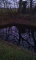
The Hashpool, Eel's Foot / Mirrormere

Drat - Temporarily Blinded


