Difference between revisions of "2017-03-01 52 1"
From Geohashing
imported>Sourcerer m ([live picture] Double Drat. [http://www.openstreetmap.org/?lat=52.44897187&lon=1.71527803&zoom=16&layers=B000FTF @52.4490,1.7153]) |
imported>Sourcerer m (→New expedition) |
||
| Line 1: | Line 1: | ||
| − | + | {{meetup graticule | |
| − | |||
| − | |||
| − | |||
| − | |||
| − | |||
| − | |||
| − | |||
| − | |||
| − | |||
| − | {{meetup graticule | ||
| lat=52 | | lat=52 | ||
| lon=1 | | lon=1 | ||
| date=2017-03-01 | | date=2017-03-01 | ||
| + | | graticule_name=Norwich, UK | ||
| + | | graticule_link=Norwich, United Kingdom | ||
}} | }} | ||
| − | |||
| − | |||
__NOTOC__ | __NOTOC__ | ||
| + | == Location == | ||
| − | + | Pakefield Industriual Estate, Suffokk, UK. | |
| − | |||
== Participants == | == Participants == | ||
| − | + | ||
| − | + | [[User:Sourcerer|Sourcerer]] | |
== Plans == | == Plans == | ||
| − | |||
| − | + | Combine this trip with my weekly shop. | |
| − | |||
| − | == | + | == Expedition - Fail == |
| − | |||
| − | + | The road came within 16 metres of the hashpoint. Google Street View showed waste land and a low rabbit fence. On arrival, there was a new building will 2 metre high security fences. This outing was combined with my weekly shop so it was not a huge waste of time. | |
| − | |||
| − | |||
| − | |||
| − | |||
| + | == Photos == | ||
| + | <gallery caption="Gallery" widths="200px" heights="200px" perrow="3"> | ||
Image:2017-03-01_52_1_Sourcerer_1488399882549.jpg | Drat. [http://www.openstreetmap.org/?lat=52.44895041&lon=1.71535313&zoom=16&layers=B000FTF @52.4490,1.7154] | Image:2017-03-01_52_1_Sourcerer_1488399882549.jpg | Drat. [http://www.openstreetmap.org/?lat=52.44895041&lon=1.71535313&zoom=16&layers=B000FTF @52.4490,1.7154] | ||
| − | |||
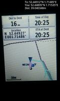
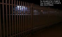
Image:2017-03-01_52_1_Sourcerer_1488399985844.jpg | Double Drat. [http://www.openstreetmap.org/?lat=52.44897187&lon=1.71527803&zoom=16&layers=B000FTF @52.4490,1.7153] | Image:2017-03-01_52_1_Sourcerer_1488399985844.jpg | Double Drat. [http://www.openstreetmap.org/?lat=52.44897187&lon=1.71527803&zoom=16&layers=B000FTF @52.4490,1.7153] | ||
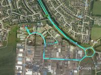
| + | Image:2017-03-01_52_1_Sourcerer.jpg | Google Earth Track | ||
</gallery> | </gallery> | ||
== Achievements == | == Achievements == | ||
{{#vardefine:ribbonwidth|800px}} | {{#vardefine:ribbonwidth|800px}} | ||
| − | |||
| − | + | {{Sourcerer_links | |
| − | + | | prev = 2017-02-26 52 1 | |
| − | + | | curr = 2017-03-01 52 1 | |
| − | + | | next = 2017-03-02 52 1 | |
| − | + | | date = 2017-03-01 | |
| − | + | }} | |
| − | |||
| − | |||
| − | |||
| − | -- | ||
| − | |||
| − | |||
| − | |||
[[Category:Expeditions]] | [[Category:Expeditions]] | ||
| − | |||
[[Category:Expeditions with photos]] | [[Category:Expeditions with photos]] | ||
| − | |||
| − | |||
| − | |||
| − | |||
| − | |||
| − | |||
| − | |||
| − | |||
| − | |||
[[Category:Coordinates not reached]] | [[Category:Coordinates not reached]] | ||
| − | |||
| − | |||
| − | |||
| − | |||
| − | |||
| − | |||
| − | |||
| − | |||
| − | |||
| − | |||
| − | |||
| − | |||
| − | |||
| − | |||
Revision as of 21:41, 1 March 2017
| Wed 1 Mar 2017 in Norwich, UK: 52.4491190, 1.7148496 geohashing.info google osm bing/os kml crox |
Location
Pakefield Industriual Estate, Suffokk, UK.
Participants
Plans
Combine this trip with my weekly shop.
Expedition - Fail
The road came within 16 metres of the hashpoint. Google Street View showed waste land and a low rabbit fence. On arrival, there was a new building will 2 metre high security fences. This outing was combined with my weekly shop so it was not a huge waste of time.
Photos
- Gallery
Drat. @52.4490,1.7154
Double Drat. @52.4490,1.7153
Google Earth Track


Achievements
Expeditions and Plans
| 2017-03-01 | ||
|---|---|---|
| Christchurch, New Zealand | Quaternary | Bottle Lake Forest Park, Christchurch, New Zealand |
| Buffalo, New York | Pedalpusher, Simon the dog, Myka the dog | In the woods off a bike path in Clarence |
| Norwich, United Kingdom | Sourcerer | Pakefield Industriual Estate, Suffolk, UK. |
Sourcerer's Expedition Links
2017-02-26 52 1 - 2017-03-01 52 1 - 2017-03-02 52 1 - KML file download of Sourcerer's expeditions for use with Google Earth.