Difference between revisions of "2018-08-10 33 -118"
From Geohashing
imported>Mckaysalisbury (adding GPS image.) |
imported>Mckaysalisbury (Adding grin) |
||
| Line 1: | Line 1: | ||
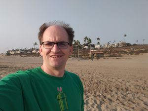
| + | [[Image:2018-08-10 33 -118 grin.jpg|grin|thumb|left]] | ||
| − | |||
| − | |||
| − | |||
| − | |||
| − | |||
| − | |||
| − | |||
| − | |||
| − | |||
{{meetup graticule | {{meetup graticule | ||
| lat=33 | | lat=33 | ||
| Line 36: | Line 28: | ||
<gallery perrow="5"> | <gallery perrow="5"> | ||
Image:2018-08-10 33 -118 gps.png | Image:2018-08-10 33 -118 gps.png | ||
| + | Image:2018-08-10 33 -118 grin.jpg | ||
</gallery> | </gallery> | ||
Revision as of 06:27, 11 August 2018
| Fri 10 Aug 2018 in 33,-118: 33.9495280, -118.4471061 geohashing.info google osm bing/os kml crox |
Location
On Playa Del Rey beach (near LAX)
Participants
Plans
I might head over after work.
Expedition
I headed over, Google Maps first showed that there was street parking, but that was way packed. The driving directions for inside the park implied I would be able to drive closer than I could, so I had to walk about a mile.
Photos
Forthcoming


