Difference between revisions of "2008-06-07 39 -119"
imported>Paveman m (Corrected tense) |
imported>Paveman (Style edit. Photos moved into a gallery, meetup graticule template employed.) |
||
| Line 1: | Line 1: | ||
| − | + | {{meetup graticule | |
| − | + | | map=<map lat="39" lon="-119" date="2008-06-07" /> | |
| + | | lat=47 | ||
| + | | lon=-122 | ||
| + | | date=2008-06-07 | ||
| + | }} | ||
The geo hash location for the [[Reno, Nevada]] graticule on [[2008-06-07|7 June 2008]] was successfully visited by [[user:Paveman|Paveman]]. | The geo hash location for the [[Reno, Nevada]] graticule on [[2008-06-07|7 June 2008]] was successfully visited by [[user:Paveman|Paveman]]. | ||
== The Location == | == The Location == | ||
| − | [[Image:2008-06-07_39_- | + | |
| − | + | [[Image:2008-06-07_39_-119_01.JPG|thumb|left|The view to the north.]] | |
[http://irc.peeron.com/xkcd/map/map.html?date=2008-06-07&lat=39&long=-120&zoom=8&abs=1 Coordinate map] | [http://irc.peeron.com/xkcd/map/map.html?date=2008-06-07&lat=39&long=-120&zoom=8&abs=1 Coordinate map] | ||
| Line 13: | Line 17: | ||
== The Meetup == | == The Meetup == | ||
| − | |||
| − | |||
| − | |||
[[user:Paveman|Paveman]] arrived at the meetup location at approximately 4:30 PM. I hadn't anticipated some of the motoring conditions. The meetup location was approximately 500 feet south of Gas Line Road, between Fernley and Crystal Springs. As the name implies, Gas Line Road is primarily driven by local utility employees, who likely have vehicles with much higher ground clearances than mine. | [[user:Paveman|Paveman]] arrived at the meetup location at approximately 4:30 PM. I hadn't anticipated some of the motoring conditions. The meetup location was approximately 500 feet south of Gas Line Road, between Fernley and Crystal Springs. As the name implies, Gas Line Road is primarily driven by local utility employees, who likely have vehicles with much higher ground clearances than mine. | ||
| Line 41: | Line 42: | ||
| Dust devils encountered || 2 | | Dust devils encountered || 2 | ||
|} | |} | ||
| + | |||
| + | == Photo Gallery == | ||
| + | |||
| + | <gallery> | ||
| + | Image:2008-06-07_39_-119_02.JPG|Makes a cowboy proud. | ||
| + | Image:2008-06-07 39 -119 03.JPG|Coffee and other refreshments were served. | ||
| + | Image:2008-06-07 39 -119 05.JPG|The marker, built with nearby rocks. | ||
| + | Image:2008-06-07 39 -119 04.JPG|GPS coordinates as presented on an LCD. This was the most readable photo of the display. | ||
| + | </gallery> | ||
| + | |||
== Getting Around == | == Getting Around == | ||
| Line 46: | Line 57: | ||
While Nevadans are familiar with the basic rules of BLM lands, some things bear repeating. | While Nevadans are familiar with the basic rules of BLM lands, some things bear repeating. | ||
* "The boundaries between grazing allotments are fenced as are the boundaries between public and private land. On higher volume roads there will be a "cattle-guard" on the road which is passable by vehicles but not by cattle. Lower volume roads will have a gate across the road. Always leave the gate in the same condition as you found it - if open leave it open, if closed make sure you close it behind you. Gates leading into private land will sometimes be locked or marked with a "No Trespassing" sign, in which case you should respect the property owner's wishes and find another way to get where you want to go." (Source: [http://wikitravel.org/en/Nevada]) | * "The boundaries between grazing allotments are fenced as are the boundaries between public and private land. On higher volume roads there will be a "cattle-guard" on the road which is passable by vehicles but not by cattle. Lower volume roads will have a gate across the road. Always leave the gate in the same condition as you found it - if open leave it open, if closed make sure you close it behind you. Gates leading into private land will sometimes be locked or marked with a "No Trespassing" sign, in which case you should respect the property owner's wishes and find another way to get where you want to go." (Source: [http://wikitravel.org/en/Nevada]) | ||
| + | |||
| + | [[Category:Expeditions with photos]] | ||
| + | [[Category:Expeditions]] | ||
Revision as of 08:27, 8 June 2008
| Sat 7 Jun 2008 in 47,-122: 47.5017842, -122.1143708 geohashing.info google osm bing/os kml crox |
The geo hash location for the Reno, Nevada graticule on 7 June 2008 was successfully visited by Paveman.
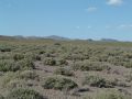
The Location

The meetup was located on Bureau of Land Management land. It's about 500 feet south of Gas Line Road, an unpaved utility road. It's range land near the center of the triangle formed by US 50, US 50 Alternate, and US 95 Alternate. Also, the meetup was about 3 miles northwest of Lahontan Reservoir.
The Meetup
Paveman arrived at the meetup location at approximately 4:30 PM. I hadn't anticipated some of the motoring conditions. The meetup location was approximately 500 feet south of Gas Line Road, between Fernley and Crystal Springs. As the name implies, Gas Line Road is primarily driven by local utility employees, who likely have vehicles with much higher ground clearances than mine.
After a bumpy ride, I found the location to be stark, barren, and other-worldly. About every meter in any direction, there were small bushes. The location itself was near the bottom of a valley carved in rolling desert hills. Very cowboy cliché.
Once the requisite proof photos were taken, I unfurled a towel, built and ate a sandwich, and consumed a cup of strong coffee. Once the marker was made (completed at 5:50 PM), I departed.
Statistics
| Arrival time | 4:30 PM |
| Geo hashers present | 1 |
| Lizards encountered | 3 |
| Cow pies encountered | 6 |
| Cow pies stepped in | 1 |
| Dust devils encountered | 2 |
Photo Gallery
Makes a cowboy proud.
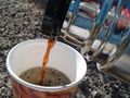
Coffee and other refreshments were served.
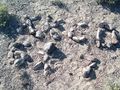
The marker, built with nearby rocks.
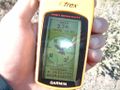
GPS coordinates as presented on an LCD. This was the most readable photo of the display.


Getting Around
While Nevadans are familiar with the basic rules of BLM lands, some things bear repeating.
- "The boundaries between grazing allotments are fenced as are the boundaries between public and private land. On higher volume roads there will be a "cattle-guard" on the road which is passable by vehicles but not by cattle. Lower volume roads will have a gate across the road. Always leave the gate in the same condition as you found it - if open leave it open, if closed make sure you close it behind you. Gates leading into private land will sometimes be locked or marked with a "No Trespassing" sign, in which case you should respect the property owner's wishes and find another way to get where you want to go." (Source: [1])