Difference between revisions of "2022-07-18 58 5"
From Geohashing
(→Achievements) |
(→Achievements) |
||
| Line 57: | Line 57: | ||
{{land geohash |name=[[User:Pica42|Pica42]] |date=2022-07-18 |latitude=58 |longitude=5 }} | {{land geohash |name=[[User:Pica42|Pica42]] |date=2022-07-18 |latitude=58 |longitude=5 }} | ||
| + | {{consecutive geohash 2 | ||
| + | | count = 2 | ||
| + | | latitude = 58 | ||
| + | | longitude = 5 | ||
| + | | date = 2022-07-18 | ||
| + | | name = Pica42 | ||
| + | }} | ||
{{Two to the N achievement | {{Two to the N achievement | ||
Revision as of 13:26, 20 July 2022
| Mon 18 Jul 2022 in 58,5: 58.8752307, 5.8593802 geohashing.info google osm bing/os kml crox |
Location
A headland that juts out into Lutsivatnet, Sandnes, Norway.
Participants
Plans
Expedition
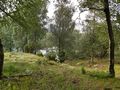
The trip to today's hashpoint took place in an area near Lake Lutsivannet in Sandnes municipality, Norway. I had to walk through an area where cows were grazing. It was very wet and dirty so it took longer to get there than I had planned. Still, reaching the hashpoint was no problem.
Tracklog
Photos

Lutsi @58.8752,5.8594
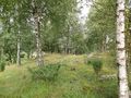
View to Storevågen
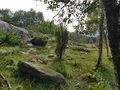
View to the northwest
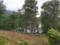
View to the southwest
View to Forenessunda


Achievements
Pica42 earned the Land geohash achievement
|
Pica42 earned the Consecutive geohash achievement
|

Pica42 earned the Two to the N achievement
by being the location of 24 expeditions on 2022-07-19 58 5 and is promoted to Level 4 (Coordinates reached).