Difference between revisions of "2024-08-09 51 6"
Coyotebush (talk | contribs) (→Expedition: story) |
Coyotebush (talk | contribs) (→Achievements: categories) |
||
| Line 51: | Line 51: | ||
| − | |||
| − | |||
__NOTOC__ | __NOTOC__ | ||
| − | |||
| − | |||
| − | |||
[[Category:Expeditions]] | [[Category:Expeditions]] | ||
| Line 64: | Line 59: | ||
[[Category:Coordinates reached]] | [[Category:Coordinates reached]] | ||
| − | |||
| − | |||
| − | |||
| − | |||
| − | |||
| − | |||
| − | |||
| − | |||
Revision as of 16:47, 19 August 2024
| Fri 9 Aug 2024 in 51,6: 51.4918039, 6.9879966 geohashing.info google osm bing/os kml crox |
Location
A park in the Vogelheim district of Essen.
Participants
Plans
Train to nearby station Bergeborbeck or Altenessen, then bike.
Expedition
- Transferring at Oberhausen. ETA 13:00 unless I stop for lunch first. -- Coyotebush (talk) @51.4747,6.8521 12:32, 9 August 2024 (GMT+02:00)
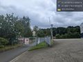
I biked from the Bergeborbeck station. Garmin routed me straight up Hafenstraße, while Google suggested possibly using the path along the creek. Hafenstraße had a bike lane to start, but that disappeared at the first intersection and the ride got more stressful. I located the creek path and found it thoroughly closed - oh well.
I turned onto, then crossed, Vogelheimer Straße and entered the park. Garmin led me on the paths right to the point - no walking needed.
Now I was definitely hungry, so I returned to Vogelheimer Straße and found a döner shop. Soon after I ordered, it started raining, and the very friendly shopkeeper offered to let me move my bike into the building hallway. By the time I finished eating, it was mostly dry out again.
I tried another Google-suggested back route that could have also led to Altenessen for a wider selection of trains, but this also hit a closure, so I had to go down Hafenstraße to the Bergeborbeck station again.
Photos

never mind about the creek path @51.4870,6.9800
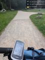
reached by bike @51.4918,6.9880

grin @51.4918,6.9880
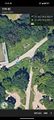
map screenshot

Döner in the rain @51.4908,6.9893
no access here either @51.4881,6.9852


