Difference between revisions of "User:Taner"
From Geohashing
imported>Taner m (photo) |
imported>Taner (new expeds) |
||
| Line 11: | Line 11: | ||
=== 2011 Expeditions === | === 2011 Expeditions === | ||
[[Image:Arrow2.png|12px]] [[2011-06-29 -37 144]] - A plot of land on Long Forest Rd<br/> | [[Image:Arrow2.png|12px]] [[2011-06-29 -37 144]] - A plot of land on Long Forest Rd<br/> | ||
| + | [[Image:Arrow2.png|12px]] [[2011-07-01 -37 144]] - A plot of land in Little River<br/> | ||
| + | [[Image:Arrow2.png|12px]] [[2011-07-03 -38 144]] - 300 metres into the sea at Clifton Springs<br/> | ||
== Geohash Achievements == | == Geohash Achievements == | ||
Revision as of 12:09, 3 July 2011
About Me

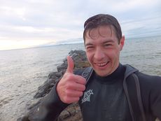
Taner at 2011-06-29 -37 144 geohash
One can never have enough hobbies, so I decided to try out geohashing after hearing about it from fellow Melbourne geohasher Felix Dance.
I don't know what I plan to do with this pursuit but after my first and very enjoyable expedition, I'm sure there will be more.
All Geohashes
2011 Expeditions
![]() 2011-06-29 -37 144 - A plot of land on Long Forest Rd
2011-06-29 -37 144 - A plot of land on Long Forest Rd
![]() 2011-07-01 -37 144 - A plot of land in Little River
2011-07-01 -37 144 - A plot of land in Little River
![]() 2011-07-03 -38 144 - 300 metres into the sea at Clifton Springs
2011-07-03 -38 144 - 300 metres into the sea at Clifton Springs
Geohash Achievements
Taner earned the Land geohash achievement
|
Taner earned the Bicycle geohash achievement
|
Taner earned the Midnight Geohash achievement
|
Taner earned the Camping geohash achievement
|