Difference between revisions of "2012-07-21 63 22"
imported>Etn (Created page with "{{subst:Expedition |lat = 63 |lon = 22 |date = 2012-07-21 }}") |
imported>Etn |
||
| Line 1: | Line 1: | ||
| − | |||
| − | |||
| − | |||
| − | |||
| − | |||
| − | |||
| − | |||
| − | |||
| − | |||
| − | |||
{{meetup graticule | {{meetup graticule | ||
| lat=63 | | lat=63 | ||
| lon=22 | | lon=22 | ||
| date=2012-07-21 | | date=2012-07-21 | ||
| + | | graticule_name=Pietarsaari | ||
| + | | graticule_link=Pietarsaari, Finland | ||
}} | }} | ||
| − | |||
__NOTOC__ | __NOTOC__ | ||
== Location == | == Location == | ||
| − | + | The hash was located in Isokyrö, on a field. | |
== Participants == | == Participants == | ||
| − | + | [[user:Etn|etn]] | |
| − | |||
== Plans == | == Plans == | ||
| − | + | There was no plan, I just had free time and noticed the hash was not too far away from home. | |
== Expedition == | == Expedition == | ||
| − | + | I left my house with nothing but my phone to track my location. I had first checked The location from Google Maps to have even some sort of idea where I was going and drove near the hash. There I noticed it was right in the middle of the field. Phone in hand, I walked and tried to find the exact location with GPS, then took a photo of it. I was travelling alone and it was quite calming to be almost in the middle of nowhere without any traffic or other people. | |
| − | == | + | == Photos == |
| − | |||
| − | |||
| − | |||
| − | |||
| − | |||
<gallery perrow="5"> | <gallery perrow="5"> | ||
| + | Image:2012-07-21_63_22Location.jpg | Close enough. I'm pretty sure I walked over the exact location at some point. | ||
| + | Image:2012-07-21_63_22Meeee.jpg | Me with my phone in the middle of the field | ||
| + | Image:2012-07-21_63_22Panorama.jpg | The view from the hash | ||
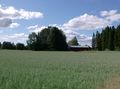
| + | Image:2012-07-21_63_22Barn.jpg | Nothing but on old barn here... | ||
| + | Image:2012-07-21_63_22House.jpg | ...except that somebody lives right next to the hash. | ||
| + | |||
</gallery> | </gallery> | ||
== Achievements == | == Achievements == | ||
{{#vardefine:ribbonwidth|800px}} | {{#vardefine:ribbonwidth|800px}} | ||
| − | + | {{land geohash | |
| − | + | | latitude = 63 | |
| − | + | | longitude = 22 | |
| − | + | | date = 2012-07-21 | |
| − | + | | name = Etn | |
| − | + | | image = 2012-07-21_63_22Meeee.jpg | |
| − | + | }} | |
| − | |||
| − | |||
| − | |||
| − | |||
| − | |||
[[Category:Expeditions]] | [[Category:Expeditions]] | ||
| − | + | [[Category:Expeditions with photos]] | |
| − | [[Category:Expeditions with photos]] | ||
| − | |||
| − | |||
| − | |||
| − | |||
| − | |||
[[Category:Coordinates reached]] | [[Category:Coordinates reached]] | ||
| − | |||
| − | |||
| − | |||
| − | |||
| − | |||
| − | |||
| − | |||
| − | |||
| − | |||
| − | |||
| − | |||
| − | |||
| − | |||
| − | |||
| − | |||
| − | |||
| − | |||
| − | |||
Revision as of 14:59, 21 July 2012
| Sat 21 Jul 2012 in Pietarsaari: 63.0420860, 22.4041931 geohashing.info google osm bing/os kml crox |
Location
The hash was located in Isokyrö, on a field.
Participants
Plans
There was no plan, I just had free time and noticed the hash was not too far away from home.
Expedition
I left my house with nothing but my phone to track my location. I had first checked The location from Google Maps to have even some sort of idea where I was going and drove near the hash. There I noticed it was right in the middle of the field. Phone in hand, I walked and tried to find the exact location with GPS, then took a photo of it. I was travelling alone and it was quite calming to be almost in the middle of nowhere without any traffic or other people.
Photos
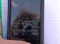
Close enough. I'm pretty sure I walked over the exact location at some point.
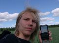
Me with my phone in the middle of the field
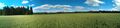
The view from the hash
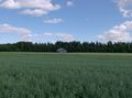
Nothing but on old barn here...
...except that somebody lives right next to the hash.


Achievements
Etn earned the Land geohash achievement
|