Difference between revisions of "2015-06-11 46 -97"
From Geohashing
imported>GeorgDerReisende |
imported>GeorgDerReisende |
||
| Line 40: | Line 40: | ||
{{#vardefine:ribbonwidth|800px}} | {{#vardefine:ribbonwidth|800px}} | ||
<!-- Add any achievement ribbons you earned below, or remove this section --> | <!-- Add any achievement ribbons you earned below, or remove this section --> | ||
| − | |||
| − | |||
| − | |||
| − | |||
| − | |||
| − | |||
| − | |||
[[Category:Expeditions]] | [[Category:Expeditions]] | ||
Revision as of 16:47, 13 June 2015
| Thu 11 Jun 2015 in 46,-97: 46.6662210, -97.0056607 geohashing.info google osm bing/os kml crox |
Location
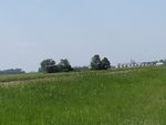
In the middle of an active farming field just north of Kindred, ND
Participants
Plans
I got off work early, and noticed that this was a virgin graticule. Hopped on my motorcycle and cruised down. There was no time to plan a meet up, and this is a fairly lonely area anyway.
Expedition
My first hash!
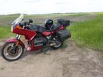
I had a great time, this was my first real motorcycle trip of the season. I got a nice face full of bugs, and got to watch the crop dusters circling nearby. My phone didn't get service out there, and I couldn't pull up my google maps that I was using to find the site. I'll never hash without my Garmin again. I decided not to walk into the field, don't know what's growing, or if the seedlings were fragile. I parked in the little pull-off just west of the hash.
Photos
|

