Difference between revisions of "2018-05-21 50 6"
imported>FelixTheCat (Created page with "{{subst:Expedition |lat = 50 |lon = 6 |date = 2018-05-21 }}") |
imported>FelixTheCat |
||
| Line 1: | Line 1: | ||
| − | |||
| − | |||
| − | |||
| − | |||
| − | |||
| − | |||
| − | |||
| − | |||
| − | |||
| − | |||
{{meetup graticule | {{meetup graticule | ||
| lat=50 | | lat=50 | ||
| Line 14: | Line 4: | ||
| date=2018-05-21 | | date=2018-05-21 | ||
}} | }} | ||
| − | |||
| − | |||
__NOTOC__ | __NOTOC__ | ||
| − | |||
== Location == | == Location == | ||
| − | + | In the forest near Großhau, kreis Düren, Germany. | |
== Participants == | == Participants == | ||
| − | + | [[User:FelixTheCat|FelixTheCat]] ([[User talk:FelixTheCat|talk]]) | |
| − | |||
| − | + | Kat the Awesome | |
| − | |||
== Expedition == | == Expedition == | ||
| − | + | Today being the 10th anniversary of Geohashing, of course I wanted to go on an expedition. Alas, no easily reachable points were nearby, the closest candidate being in 50,6 near Aachen. But luckily today was a national holiday and I had no other plans. I managed to convince Kat to go on a day trip, first to do some sightseeing in Maastricht (and eat some ''vlaai'', or pie, the local delicacy), and then to take a walk in a forest just across the border in Germany. | |
| + | |||
| + | It was quite a long drive (about 2.5 hours each way) but we had a lot of fun both in Maastricht and in the forest. The weather was nice, we found the hashpoint and a good time was had by all :-) | ||
| − | + | Happy Geohashing Day everyone! | |
| − | |||
== Photos == | == Photos == | ||
| − | |||
| − | |||
| − | |||
<gallery perrow="5"> | <gallery perrow="5"> | ||
| + | Image:2018-05-21 50 6 FelixTheCat 1.JPG | First stop: Maastricht. Eating ''vlaai'' in a cute little café. | ||
| + | Image:2018-05-21 50 6 FelixTheCat 2.JPG | The entrance road into the forest. | ||
| + | Image:2018-05-21 50 6 FelixTheCat 3.JPG | The road becomes less and less paved. | ||
| + | Image:2018-05-21 50 6 FelixTheCat 4.JPG | And even less. | ||
| + | Image:2018-05-21 50 6 FelixTheCat 5.JPG | And for the last bit there isn't even a path. The hash is about 150 metres ahead from here. | ||
| + | Image:2018-05-21 50 6 FelixTheCat 6.JPG | Right here! X marks the spot. | ||
| + | Image:2018-05-21 50 6 FelixTheCat 7.png | GPS proof. | ||
| + | Image:2018-05-21 50 6 FelixTheCat 8.JPG | Lloyd celebrating Geohashing Day. | ||
| + | Image:2018-05-21 50 6 FelixTheCat 9.JPG | The surroundings. | ||
| + | Image:2018-05-21 50 6 FelixTheCat 10.JPG | And the hashpoint again. | ||
</gallery> | </gallery> | ||
== Achievements == | == Achievements == | ||
{{#vardefine:ribbonwidth|800px}} | {{#vardefine:ribbonwidth|800px}} | ||
| − | + | {{Geohashing Day | |
| − | + | | latitude = 50 | |
| − | + | | longitude = 6 | |
| − | + | | year = 2018 | |
| − | + | | coorddate = 2018-05-21 | |
| − | + | | name = [[User:FelixTheCat|FelixTheCat]] ([[User talk:FelixTheCat|talk]]) | |
| − | + | }} | |
| − | |||
| − | |||
| − | |||
| − | |||
| − | |||
| − | |||
| − | |||
| − | |||
| − | |||
[[Category:Expeditions]] | [[Category:Expeditions]] | ||
| − | |||
[[Category:Expeditions with photos]] | [[Category:Expeditions with photos]] | ||
| − | |||
| − | |||
| − | |||
| − | |||
| − | |||
[[Category:Coordinates reached]] | [[Category:Coordinates reached]] | ||
| − | |||
| − | |||
| − | |||
| − | |||
| − | |||
| − | |||
| − | |||
| − | |||
| − | |||
| − | |||
| − | |||
| − | |||
| − | |||
| − | |||
| − | |||
| − | |||
| − | |||
| − | |||
Revision as of 21:15, 26 May 2018
| Mon 21 May 2018 in 50,6: 50.7499123, 6.3766712 geohashing.info google osm bing/os kml crox |
Location
In the forest near Großhau, kreis Düren, Germany.
Participants
Kat the Awesome
Expedition
Today being the 10th anniversary of Geohashing, of course I wanted to go on an expedition. Alas, no easily reachable points were nearby, the closest candidate being in 50,6 near Aachen. But luckily today was a national holiday and I had no other plans. I managed to convince Kat to go on a day trip, first to do some sightseeing in Maastricht (and eat some vlaai, or pie, the local delicacy), and then to take a walk in a forest just across the border in Germany.
It was quite a long drive (about 2.5 hours each way) but we had a lot of fun both in Maastricht and in the forest. The weather was nice, we found the hashpoint and a good time was had by all :-)
Happy Geohashing Day everyone!
Photos
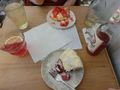
First stop: Maastricht. Eating vlaai in a cute little café.
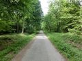
The entrance road into the forest.
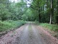
The road becomes less and less paved.
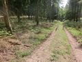
And even less.
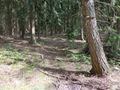
And for the last bit there isn't even a path. The hash is about 150 metres ahead from here.
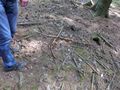
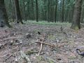
Right here! X marks the spot.
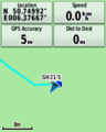
GPS proof.
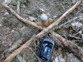
Lloyd celebrating Geohashing Day.
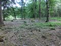
The surroundings.
And the hashpoint again.


Achievements
FelixTheCat (talk) earned the 2018 Geohashing Day achievement
|