File:Chicago semigraticule.png
From Geohashing
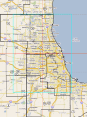
Revision as of 20:05, 21 May 2008 by imported>Joeuth (This map includes approximate county lines as well as the border of Chicago in black. It also includes graticule divisions in red as well as a proposed shift of the Chicago graticule 0.5 degree north and west in blue.)

Size of this preview: 447 × 600 pixels. Other resolutions: 179 × 240 pixels | 545 × 731 pixels.
Original file (545 × 731 pixels, file size: 108 KB, MIME type: image/png)
This map includes approximate county lines as well as the border of Chicago in black. It also includes graticule divisions in red as well as a proposed shift of the Chicago graticule 0.5 degree north and west in blue.
File history
Click on a date/time to view the file as it appeared at that time.
| Date/Time | Thumbnail | Dimensions | User | Comment | |
|---|---|---|---|---|---|
| current | 17:06, 30 January 2020 | | 545 × 731 (108 KB) | Maintenance script (talk | contribs) |
- You cannot overwrite this file.
File usage
There are no pages that link to this file.