2013-04-28 47 11
From Geohashing
Revision as of 14:54, 28 April 2013 by imported>LeslieHapablap (→Achievements)
| Have you seen our geohashing marker? We'd love to hear from you! Click here to say "hi" and tell us what you've seen!
Curious about what geohashing is? Read more! |
| Sun 28 Apr 2013 in 47,11: 47.2958254, 11.4715725 geohashing.info google osm bing/os kml crox |
Location
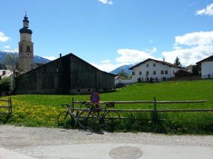
In the middle of the village Thaur, opposite to the priest's office. Seems to be some kind of field, might be private ground.
Participants
on our very first hash.
Plans
We plan to go there by bike from Innsbruck, reaching the hash point at about 2pm. We will continue to Hall and then back to Innsbruck along the Inn.
The hash point should not be too hard to reach, except if it is private ground fiercely defended by locals.
Expedition
- Here we go... beautiful day! -- LeslieHapablap (talk) 13:26, 28 April 2013 (CET)
- We reached the coordinates. This was way too easy, but a nice first hash. -- LeslieHapablap (talk) @47.2959,11.4717 14:04, 28 April 2013 (CET)
This hash was located just a few hundred meters off from one of our usual biking routes. The expedition was pretty uneventful, but fun nevertheless. On our way back we made a small detour to find a hashcat, and we did!
Tracklog
Photos
Achievements
LeslieHapablap and EleanorAbernathy earned the Land geohash achievement
|
LeslieHapablap and EleanorAbernathy earned the Bicycle geohash achievement
|
LeslieHapablap and EleanorAbernathy earned the Hashcat achievement
|


