2015-08-14 52 1
From Geohashing
Revision as of 23:46, 14 August 2015 by imported>Sourcerer (→New expedition)
| Fri 14 Aug 2015 in 52,1: 52.0077248, 1.3059386 geohashing.info google osm bing/os kml crox |
Location
25 metres north of a public footpath, west of Kirton, Suffolk, UK.
Participants
Plans
Expedition one of two spanning midnight - 2015-08-14 52 1 - 2015-08-15 52 1 - ETA 22:40.
Expedition
- Arrived. -- Sourcerer (talk) @52.0077,1.3059 22:24, 14 August 2015 (GMT+01:00)
This was easy to find because it was close to hashpoints I had visited earlier. There was a public footpath / farm access road. This swung round to the right and the hashpoint was in the stubble of a wheat or barley field about 25 metres from the path.
Photos
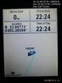
Proof. @52.0077,1.3059
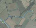
Track in Google Earth


Achievements

Sourcerer issued a challenge for the Tale of Two Hashes achievement
by geohashing in a place named Innocence (lane) from the (52, 1) geohash on 2015-08-14.
Expeditions and Plans
| 2015-08-14 | ||
|---|---|---|
| Mannheim, Germany | elimik31 | Close to the Rhine harbor in Karlsruhe, 10 m from a gravel track in a fores... |
| Frankfurt am Main, Germany | Tads | on a playground in Mainz-Kostheim |
| Halle (Saale), Germany | Reinhard | At the hillside of inglorious Ettersberg north of Weimar, Germany. |
| Norwich, United Kingdom | Sourcerer | 25 metres north of a public footpath, west of Kirton, Suffolk, UK. |
Sourcerer's Expedition Links
2015-08-12 52 1 - 2015-08-14 52 1 - 2015-08-15 52 1 - KML file download of Sourcerer's expeditions for use with Google Earth.