2019-07-22 54 13
| Mon 22 Jul 2019 in Greifswald, Germany: 54.0256305, 13.3150553 geohashing.info google osm bing/os kml crox |
Contents
Location
Between two field, between Dersekow and Dargelin, MV, Germany.
Participants
Plans
The hash is not so far of Greifswald, so my intention is to go there in the morning (since, if it has to rain today it will be in the afternoon), and I expect to complete the expedition in 2-3 hours. It does not seem easy though, since it's located between two fields.
Expedition
Geohashing did it again. It fell close from Greifswald, but it helped me to discover some new paths I still had not discovered. So many hidden places.
I grabbed Winterbuche at 12:00, so I expect to have lunch back home in a few hours. It didn't look too cloudy yet, but windy, just enough to annoy the usual biker ;) But that is something normal up here, and you just end up getting used to it.
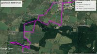
After Greifswald I went south towards Helmshagen I and II. Here I continued south until I reached the road that goes to Dersekow, and turned left going into new paths not yet discovered by me. Went between some various fields, some harvested some not, crossed the Schwinge (small river) and approach the forest north of the field where the hash fell. Here I found some paths that are not mapped on OSM and helped me to approach the division between the two field where the hash fell. At some point here I parked Winterbuche and continued by feet.
Since the two fields where quite different it was quite easy two walk there without damaging any plants. One field had rapeseed, which makes it kind of dense and only walkable through the tractor tracks (as I had to do here) but in the other field was planted with sugar beets, which makes it easy to avoid if you walk through. Actually, I believe Germany is a big exporter of Sugar beets. Many of the fields in the area have them. I encountered them in my second hash.
So, I walked between the two fields, and at a given moment I found some "path" made by a deer (deduced it by the faeces I found there) that helped me reach the tractor tracks in the rapeseed field. And following them I got to reach the hash location.
Back at Winterbuche I went through the roads in this forest area, so that I could map them later in OSM. It ended up being a quite nice area. What I didn't know is that it was a natural protected area.
However it was not everything so easy. Somewhere in these paths, maybe going a little bit to fast, but a branch got stuck between the pedals and chain of the bike, and made me stop. It even moved the rear wheel so that it wouldn't move. Ahh-- damn... Luckily enough, I had my tools with me. I usually keep them in another bag, but for some unknown reason, I decided to take my adjustable spanner with me. Which I ended up needing. Lucky me, it would have been painful to walk from here to home. So 5 minutes to bring Winterbuche back to normality and continued.
After that no more problems. Reaching the outskirts of Greifswald I felt some thin rain drops, but no many. Hardly noticeable. But I was already only 20 minutes from home, so I had no worries. And that's it. 2:45 minutes, as planned. And this is how a close hash helped me discover new paths in the area. I believe you never get to know perfectly your surroundings, which gives you room to be amazed most often :)
Tracklog
Photos
Achievements
SastRe.O earned the Land geohash achievement
|
SastRe.O with Winterbuche earned the Bicycle geohash achievement
|
SastRe.O earned the OpenStreetMap achievement
|
Other Geohashing Expeditions and Plans on This Day
Expeditions and Plans
| 2019-07-22 | ||
|---|---|---|
| Tri Cities, Washington | Thomcat | A farmer's field east of Grandview, north of Prosser. |
| Braunschweig, Germany | Fippe | located on a field near Alt Wallmoden. |
| Stralsund, Germany | SastRe.O | Between two fields, between Dersekow and Dargelin, MV, Germany. |
| Hamar, Norway | MaxMad | In an open field under the power lines close to Rånåsfoss hydro plant. Park... |


