2013-08-02 54 -1
| <map lat="54" lon="-1" date="<strong class="error">Error: Invalid time.</strong>"></map> | ||
| [[Error: Invalid time. | Error: Invalid time.]] in 54,-1: Expression error: Unexpected < operator.54.5868315, Expression error: Unexpected < operator.-1.3879914 not yet announced |
[[Category:Meetup on Error: Invalid time.]]
Location
Along a tree line between a cow pasture and sheep pasture, County Durham, UK
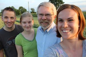
Participants
Expedition
AKA The CowHash
After a long day of work (chemistry lab for George and exploring Carlisle for Jess and Jake), George came home and noticed that the hashpoint for Friday night was about a 20 minute drive from our flats. George asked his family if they wanted to go and received 3 nays, due to a repeat of "Sherlock" being on BBC. Instead, George texted Jessica and she immediately said yes. Looking at the maps, we noticed it was going to be a walk to the hash and hastily threw our supplies together to try to reach the has before dark.
George was confident of finding his way to Esh Winning, a town near the hash, so Jess used her phone to try to get the GPS running. Once that was working, we realized we'd actually missed the turn we needed and were quite a bit south of the major road out to the hash. Checking out the paper map and the phone map, we saw a road that connected the major road we were on with the major road we wanted to be on. When we found said road, it had a sign proclaiming, "Public Footpath". It was paved (barely) and looked drivable so we decided to give it a try. After about a 1.5 miles of bumpy overgrown paved path, the road ended at a farm. It looked like the road did continue out the other side of the road but there were large, locked gates that our little Suzuki wasn't going to get through. So we turned around and went the long way around to our hashpoint.
The field for the hashpoint was easy to find at that point and we pulled the car up next to another "Public Footpath" sign. We were able to walk through a field in the last light of the day towards the L-shaped group of trees we'd noticed on the map. With the little bit of light left, we were able to step around the huge piles of cow droppings. We made it through the field and found the cows over the hill towards our hashpoint. There was another fence to climb over and as we did so, the cows started wandering over to our corner of the field. We all got over the fence and then, suddenly, the entire herd of cattle was looking to do a geohash with us! Jake, being Jake, taunted the cows by attempting to take pictures of the cows. They started mooing and then running. We were quite thankful for the fence at that point.
The field where the hash was is empty of animals currently but we did manage to find evidence of there being animals there at one point. ;) We walked along the trees judging the distances and using other trees and landmarks to triangulate our point. There was no cell service for the GPS on the phone to work. We heard many sheep in the pasture on the other side of the trees and again were thankful for a fence. The hash proved to be easy to find by staying on the tree line and using other trees to match our map. We took our pictures and were off.
To get back, we knew we had to walk through the cow pasture again. We got back to the fence to climb over and the cows were nowhere in sight. After a minor discussion about which side of the fence to walk along, we decided to risk it with the cows because we knew we could climb the fence here and we didn't know if we could up the hill. We walked through the cow pasture, again attempting to avoid cow patties, using a windmill and light from a farmhouse to find our way back to the car and the field entrance. At the top of the hill in the pasture, we noticed the cows had made there way up the hill, but were still on the other side of the field. Then they started mooing.
Apparently they were interested in GeoHashing and were annoyed we didn't let them come with us and tried to intercept us on the way out. One cow, and then another, and then another, and then some more started moving towards us. By this time it's definitely dark out and there are no lights. A herd of cows not running but moving towards you mooing in the night is enough to get your heart racing and quicken your step. We each took turns stopping and facing them which would cause a cow or two to stop in their tracks but we still hightailed it out of there. We decided not to look for the "Public Footpath" way out and just jumped the fence before the stampede got much traction.
Driving home, we congratulated ourselves on a successful hash, avoiding a stampede and not getting any cow patties on our shoes.
Photos
Achievements
George, Katja, Jake, and Jessica earned the Land geohash achievement
|
