Difference between revisions of "2008-09-06 51 11"
imported>Pari (New page: {{meetup graticule | map=<map lat="51" lon="11" date="2008-09-06" /> | lat=51 | lon=11 | date=2008-09-06 }} == About == Today's location in this graticule lies on a field near Adersleben...) |
imported>FippeBot m (Location) |
||
| (2 intermediate revisions by one other user not shown) | |||
| Line 11: | Line 11: | ||
== Expedition == | == Expedition == | ||
| + | |||
| + | Participators: [[User:Pari|pari]] | ||
I started in Halberstadt, a town about 12 kilometers (8 miles) away from the hash point. I took the bike and chose a way with few traffic to enjoy nature and be able to take some photos. | I started in Halberstadt, a town about 12 kilometers (8 miles) away from the hash point. I took the bike and chose a way with few traffic to enjoy nature and be able to take some photos. | ||
| Line 18: | Line 20: | ||
Image:2008-09-06 51 11 00011.jpg | street leading to the hash point | Image:2008-09-06 51 11 00011.jpg | street leading to the hash point | ||
Image:2008-09-06 51 11 00014.jpg | photo on the way, in the background the Brocken, highest mountain in Northern Germany | Image:2008-09-06 51 11 00014.jpg | photo on the way, in the background the Brocken, highest mountain in Northern Germany | ||
| + | Image:2008-09-06 51 11 00026.jpg | 200 meters from destination | ||
Image:2008-09-06 51 11 00028.jpg | photo of the GPS device at the destination | Image:2008-09-06 51 11 00028.jpg | photo of the GPS device at the destination | ||
</gallery> | </gallery> | ||
| Line 41: | Line 44: | ||
[[Category:Coordinates reached]] | [[Category:Coordinates reached]] | ||
| + | {{location|DE|ST|HZ}} | ||
Latest revision as of 06:52, 7 August 2019
| Sat 6 Sep 2008 in 51,11: 51.8999133, 11.1865472 geohashing.info google osm bing/os kml crox |
About
Today's location in this graticule lies on a field near Adersleben, a German village in the state of Sachsen-Anhalt. Because of a public street about 200 meters (220 yards) next to it, I guessed it shouldn't be too difficult to get there.
Expedition
Participators: pari
I started in Halberstadt, a town about 12 kilometers (8 miles) away from the hash point. I took the bike and chose a way with few traffic to enjoy nature and be able to take some photos. After leaving the town, a private street led to the village Wegeleben. From there, a small path went along farms and over the creek Bode. Behind a church and another field, I finally reached the desired point.
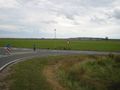
street leading to the hash point
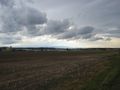
photo on the way, in the background the Brocken, highest mountain in Northern Germany
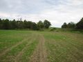
200 meters from destination
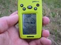
photo of the GPS device at the destination


More photos
Traffic sign telling me I may use this street with my bike
Entering the village Wegeleben
A small path through a field, about 1km (0.6 miles) from destination