2009-05-04 48 8
| Mon 4 May 2009 in Pforzheim, Germany: 48.5037358, 8.8138728 geohashing.info google osm bing/os kml crox |
Location
On a field near Rottenburg-Ergenzingen, only a few hundred metres from 2009-01-04 48 8
Expedition by Ekorren
This really wasn't one of the more thrilling expeditions. More so, it could have been a mostly exact duplicate of the expedition four months ago which went to a location only a few fields away. I started around noon, went on a well-known way to Wendelsheim, then took a number of ways that were missing in OSM (which hardly made a detour) and went for a mystery geocache that I had solved long ago. So far it's still basically a duplicate of that old expedition - I had successlessly tried to find that cache on the way to that one as well. This time, I thought I would be a bit better prepared, and ended up spending way too much time combing a forest area of about 50 m in each direction around the coordinates - once again, successlessly. I later found out that, since I had solved the riddle, the riddle had changed in a minor detail and obviously the cache had been moved...
From there, I took an almost direct way to the hash location, half circled the field it was in, and decided that I wouldn't be able to enter the field without trampling on crop. This might be called a success by some standards people have set (and I wouldn't mind to call it one, as it would have been easily possible to proceed but I just decided to restrain to make sure nothing gets damaged).
Made a minimum of photos, as there wasn't really anything to show, and went on to revisit 2009-01-04 48 8. That place hadn't been very interesting four months ago, neither it was now, so after documenting the revisit I went into hash village.
I soon gave up to search the geocaches in that village as there were people everywhere, so searching and logging them unnoticed was impossible. One reason might have been that there was some kind of market going on in the village - not the "farmers offer their local products" kind of market, but the "travelling salesmen offer the latest in plastics waste and wonder products" kind of market. There seem to be people who buy that crap, otherwise they wouldn't continue to sell it anyway.
After having filed both the market and the village under the "uninteresting" category, I turned home on another way. Mapped a small hamlet, then went to go down the Rommelstal valley. All maps I knew never showed a cyclable way through the entire valley but recommended to go through only half of it and then turn up in the hills again - which might be nice but is rather inconvenient. But recently, someone drawed two different ways on OSM connecting through the lower part to the Neckar valley, which looked very promising. I tried one of them and called that a total success, as it not only makes a convenient connection between the Neckar valley and the Oberes Gäu hills, but also is surely one of the most wild-romantic valleys we have in our area. Hooray for OSM!
At Obernau, I reached the Neckar valley and took the well-known trail home.
Gallery
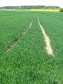
The hash field
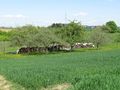
View from (near) hash
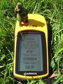
Not really reached
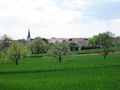
Hash Village
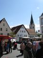
Want to spend money for useless crap? You're right here, then.
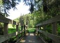
A small bridge on the way back
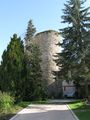
An old tower at Obernau


