2009-09-06 50 -1
| Sun 6 Sep 2009 in 50,-1: 50.8835241, -1.8030964 geohashing.info google osm bing/os kml crox |
Location
Nice-looking location in the New Forest Might be private land, but probably can get very close, and the weather forecast is excellent.
Participants
Plans
Macronencer is planning to drive to a likely-looking parking area and then do a cycling expedition across the forest to reach the hash. Hoping for a good day - the weather is looking OK.
Expedition
I was really looking forward to this trip, as it was turning out to be a lovely day and I have never cycled the route before so I'd be seeing pieces of the New Forest that were new to me. I parked in a handy parking area near Cadnam and made ready the bike and equipment. The first 8km or so were all up a gentle hill with the wind against me so it was not that easy, but I looked forward to coming back that way :) (NOTE: I've since discovered that the hill was going down on the way out and up on the way back. I think the wind fooled me!) I had used an online converter to turn a Google Maps directions list into a GPX file and put it on my eTrex. This worked OK: each waypoint was exactly on a junction though, so unfortunately I only knew which way to turn once I had reached the junction. But it worked pretty well.
After the heathland section I passed through some wooded areas, and then much hillier terrain, which was rather pretty (near the Red Shoot camp site). Went through a ford at Ibsley (I think it was there) and then spent about 300m on the A338 before turning left over a picturesque bridge at Harbridge. My eTrex instructed me to turn left, but it was a private road. I began to feel an Ely, but decided that I would press on using the public road and try to find another route. Eventually I found an entrance that clearly said PRIVATE. However, I was not going to give up so easily, and persisted in my route around the Somerley Estate, hoping that the hash might be next to a public road after all, but that I'd just have to go the long way round.
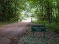
I passed an overgrown path on the left side of the road, with a Footpath sign - aha! Looked public to me. So I parked my bike on the other side of the road, chaining it to a fence near a mobile phone mast, and headed off on foot into the estate. I had scarcely gone 100m when the path ended, with a muddy track running across it. I decided to turn right, hoping that this was still the "footpath".
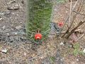
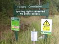
As I proceeded, my actions began to feel more and more like trespassing, though I was ready with the explanation that the footpath sign had led me astray, of course. If they don't want people coming in there, they should take it down. But the first thing I noticed was a fenced-off area with a low electric fence on the outside of it - probably to keep out foxes etc. Then I saw a hide or some kind of shed. I could hear pheasants in the woods and it occurred to me that this was a rearing pen.
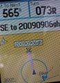
As I reached a crossroads I found pheasants running about (see photo) and a feeding machine. I was beginning to feel more and more as if I had been transported into Roald Dahl's marvelous tale, Danny the Champion of the World, which I really loved reading as a kid (and my son has now heard it on audiobook too). Any moment, I expected a gamekeeper with a shotgun to stride out of the trees and challenge me - or perhaps a red-faced Victor Hazell himself :) As I had these thoughts, I noticed that the left-hand turning from the crossroads led to a house about 200m down the track, and I could see the windows. I decided that I wasn't brave enough to continue sauntering nonchalantly through an obviously private estate, and photographed my distance from the hash (565m) before turning back.
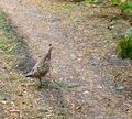
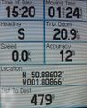
When I reached the junction with the footpath, I decided to try the track in the other direction. This soon led to another place with buildings nearby, where again I decided that I didn't really want to be spotted, so I turned back again - this time I got to 479m away (roughly - 12m accuracy), and photographed the screen - and also a pheasant, who was strolling along by a fence.
Returning to my bike, I decided to continue my circuit of the estate perimeter. The place was HUGE. I must have gone about 10km out of my way at least, compared with my original estimate. I kept looking for a public road leading left, which might have got me closer to the hash point, but the screen consistently told me that it was behind me, and this was not my lucky day.
So, I switched to backtracking mode and took the route back to the car. Unfortunately I had gone so far astray that I ended up at the A31 at Ringwood, where I had to turn left onto the A338 and do quite a long stretch on the busy road, which I had hoped to avoid.
I attempted to stop for lunch at a nice-looking green area near a church, but was immediately visited by some hungry beasts! These New Forest ponies looked suspiciously like donkeys, but I think it was I who was the ass, for thinking I could munch my sandwiches in front of them! They are so tame, they came right up to me and I was stroking their noses and giving them the bad news that my lunch was not on the menu!
Eventually I stopped somewhere away from the wildlife and managed to eat. By this time I was pretty tired, and the long haul back to the car was tough. I was very glad of the downhill stretch near the end!
So, this was my first "Co-ordinates Not Reached", but I think it's fair to say that it was not for want of trying! And it certainly was a lovely way to spend a Sunday afternoon.
Tracklog to follow soon.
Tracklog
Photos
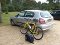
Ready for the off
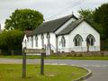
Nice little church and funny road name
Harbridge
Uh-oh... this is not going to go my way
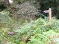
...or is it? Looks like a public right of way to me
Now it's a 4x4 track
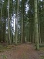
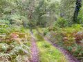
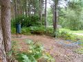
Beautiful woodland
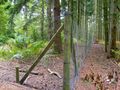
What's this? A fence...
Electrified...
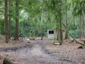
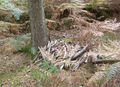
...and a gate. Probably a rearing pen
Feeder
Pheasant
If this weren't private land, I'd swear there must be a geocache under there! Didn't dare look though.
Thwarted at 565m
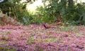
Pheasant! Around this time it occurred to me that I didn't look anything like a poacher, but that I still should hide my camera and act lost if challenged...
Slightly better - 479m. I didn't get any closer, unfortunately.
Dammit! I wish I could have got permission to go onto the land.
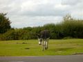
New Forest Donkey :) Or is it a pony? Whatever, it REALLY wanted my lunch - and so did its friend.
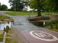
Glad this ford wasn't too deep for my bike. Note to self: check for fords next time!
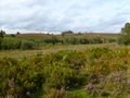
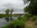
Lovely view
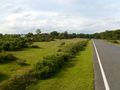
It brightened up on the way back, and the early evening sun made everything look wonderful.

Back at base camp, looking a little flushed! 48km is not bad for me. I hope to get fitter.


Achievements
Macronencer earned the No trespassing consolation prize
|