2009-09-27 48 8
| Sun 27 Sep 2009 in 48,8: 48.9587011, 8.3435791 geohashing.info google osm bing/os kml crox |
Contents
Location
In a forest near Silberstreifen, which is a part of Forchheim, which again is a part of Rheinstetten
Participants
Plans
As the federal elections were today and the 48,8 hashpoint wasn't too far, I didn't want to miss the chance for a Democracy Geohash Gratuitous Achievement.
I planned to vote at about 14:30 and then take trams 5 and 3 to Karlsruhe Ebertstraße and from there the SEV (rail replacement) bus. Why replacement? During the last year, the two rail lines (one via Bruchhausen and one via Durmersheim, Silberstreifen, where the Hashpoint is, being at the latter) between Rastatt and Karlsruhe has been under renovation. The Brucxhhausen line is currently closed, while all trains go via Durmersheim. Due to the increased traffic, the light rail can no longer stop in the villages in between, so I had to use a replacement bus. If I started at about 14:47, I would arrive in Silberstreifen at approx. 15:35.
Report
I left my home at 14:25 and walked to a nearby school to go voting. After that was done, I went to the tram stop Forststraße to catch tram 5 into the inner city, to the Kronenplatz and from there tram 3 to the Main Station, where it changed into tram 4 and brought me to Ebertstraße. There I boarded the replacement bus, which brought me to Silberstreifen by 15:35.
"Silberstreifen" translates into "Silver Stripe" . The village is actually named after the rail line which passes right through it and glazes silver in the sun. From the bus stop, I walked hashwards, also passing the town sign_ Silberstreifen (pop: 500) is a part of Forchheim (pop: 9000), though it's actually about 2 kilometers from Forchheim, yet the (currently closed) railway station, located in Silberstreifen, is called Forchheim. Forchheim again is a part of Rheinstetten (pop: 20000), a new municipality, in which the former indepentent villages of Mörsch, Forchheim and Neuburgweier were merged in 1975.
Karlsruhe's exhibition areal (Messe) is also located in Forchheim. To provide better access from the Autobahn, a tunnel was built under the village Silberstreifen.
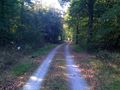
As I walked east along the main road, my GPS pointed 90° into the forest. However, I saw some paths on the satellite imagery, which I soon found and, after turning right twice (thus facing west), I could locate the hashpoint right at the forest path, but not after a rather excessive GPS dance due to dense trees above the path blocking the sky.
The hashpoint itself wasn't that interesting, as expected, nobody else was there at 16:00, so I left so I could still catch the 16:20 bus home. Using siad bus I, after changing at Ebertstraße again to tram line 4, arrived home at 17:00, still one hour before 18:00, when the pools closed and we were told the (IMHO rather disappointing) results of the election.
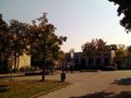
Voting took place in this school
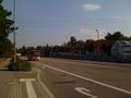
rail replacement bus in Silberstreifen
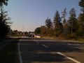
unnel under the village of Silberstreifen and the rail line
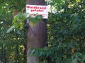
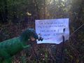
Danger of Forest Fires
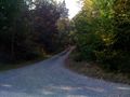
This way to the Geohash
Coordinates reached


Koepfel earned the Democracy Geohash Achievement
|