2009-10-10 41 -72

| Sat 10 Oct 2009 in 41,-72: 41.4970651, -72.3456340 geohashing.info google osm bing/os kml crox |
Location
Off the side of a road in East Haddam, Connecticut
Participants
Sara, Sara's Daughter, Sara's Son, Aunt Ruthie
Expedition
We picked up my sister at the train station, drove from there to East Haddam and parked right near the hashpoint, then walked a few meters into the woods and did a little GPS dance just until we were within GPS accuracy range (We were about 5m from the hashpoint, accuracy was about 6m). We marked the spot with a pile of sticks and the kids climbed around on fallen logs for a few minutes.
Then we drove to Devil's Hopyard State Park, just a few km from the hashpoint. My plan had been to take a little hike there, but as soon as the kids got near the river all they wanted to do was look for fish, wave sticks around in the water, and throw rocks in the water. They could have stayed there all day. I didn't realize how much they could enjoy something so simple. We could barely tear them away from the bank for long enough to walk a couple hundred meters to see the waterfall. We all enjoyed looking at the waterfall, and then walked back to the car.
On the way home, we stopped to see the exterior of Gillette Castle and later had some ice cream at a place in Middletown, CT which had really good ice cream the last time we were there but is now under new management and has okay ice cream.
It was great to see the kids enjoy playing at the river, and I'm grateful to geohashing for bringing us there.
Photos
On the Way and at the Haspoint
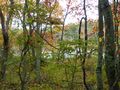
View from the hashpoint. We didn't realize there was going to be a pond there. Luckily the hashpoint was on dry land.
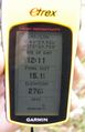
GPS

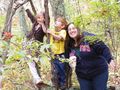
Don't my sister and I look alike? (My sister is on the right.)
The kids enjoyed balancing on logs at the hashpoint.


At Devil's Hopyard State Park
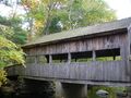
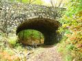
We ate lunch near this covered bridge.
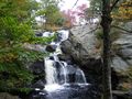
The waterfall.
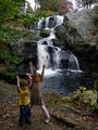
Kids and waterfall.
A view for the adults to enjoy while the kids look for pretty leaves and throw rocks in the water.
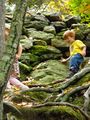
This picture doesn't capture how high up the kids were and how very steep the hill was. My heart was pounding with worry, but they loved it. (They both made it up and down uninjured.)


