2010-03-12 48 8
| Fri 12 Mar 2010 in 48,8: 48.9518244, 8.8367594 geohashing.info google osm bing/os kml crox |
Contents
Location
In Mühlacker, on the railway embankment for the connecting curve for trains from Pforzheim to Bretten.
Participants
Plans
Train to Mühlacker, walk from there. That was the plan. Timing: I was going to be at the university until about 15:00. so somewhat around 16:00-17:00
Report
I was at the university until about 15:00, I looked up trains to Mühlacker, there was a Regionalexpress going from Durlach at 15:23. So I took tram 1 to Durlach, and entered the train to Mühlacker. There would be direct trains from the inner city to Mühlacker (dual system trams, S5), but they take longer than the express train, as they stop everywhere.
In the train, I witnessed a delightful tale about love, kissing, rape and murder. Three teen girls talked loudly about some other girl they seemed to hate, who had a crush on some guy, claimed to have kissed him and later be raped by him. They then called said boy, he apparently denied it, Later, they talked about trying to poison her by spraying deodorant on her toothbrush. I didn't really get all of it, but it was rather amusing, other passengers next to me also had a hard time not bursting into laughter.
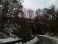
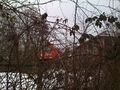
When nearing Mühlacker, I tried to take a photo of the hashpoint while arriving. Based on the map, I knew that it was located in the middle of the wye west of the Mühlacker station, at a track connecting Pforzheim and Bretten, rarely used by passenger trains.
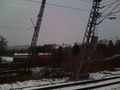
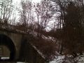
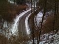
From the station, I walked west, through the inner city and along a highway, next to the train line. After a small detour down from the highway, I walked through a tunnel underneath the railway line I arrived on and found myself in the middle of the wye. There was a narrow road next to a creek, so I walked towards the next tunnel, under the Pforzheim-Bretten part of the wye. However, the closest I could get was about 10 meters, pointing into the creek. From the other side of the tunnel, the distance was even larger, I had no choice, I had to get up to the tracks. So, 10 meters distance, which also meant about 10 meters difference in height.
There was another road going up to some railway maintenance buildings, a sign said "Private road by the german federal railway (Bundesbahn)". Even though the Bundesbahn no longer exists since 1994, I chose not to enter, also it wouldn't brought me that much closer. No, I had to climb the embankment directly through the undergrowth.
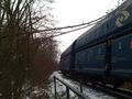
Between the dense thorns, on steep and slippery terrain (snow), it then took me about half an hour to walk the last 10 meters (obviously not directly, as I had to climb up right of the tunnel entrance and then fight my way on the other side on the top, as the creek was on the left). As I arrived on the top the the embankment, a freight train drove by and came to a stop a few hundred meters later.
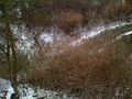
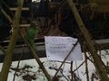
Eventually, I managed to find the hashpoint, between thorned bushes and next to the railway line, the freight train was still standing there. I wrote a marker, took photos and a video. Note how high above the road the hashpoint is. Sorry for the bad camera work, I always had to hold on to a railing with the other hand not to fail down the hill.
The way down went much easier, because even if you slip, you're still going in the right direction. There was a train going back to Karlsruhe at 17:21, which brought me back to Durlach, from where I took tram 1 back to the Kronenplatz, arriving at 18:00.
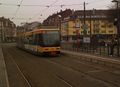
Tram to the Durlach station
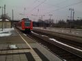
Train to Mühlacker
Arriving at Mühlacker, driving past the wye the hashpoint it at
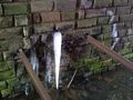
Ice at the creek in the tunnel under the railway line
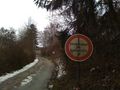
The Bundesbahn may no longer exist, the road is still private property.
Down at the road, not getting closer than 10-20 meters.
Climb up here.
At the top of the embankment. Freight train arrives.
Looking down to the road.
At the hashpoint
Reached.