2010-05-21
From Geohashing
Revision as of 22:41, 23 August 2010 by imported>ReletBot (moving from Template:auto gallery to Template:auto gallery2)
Expedition Archives from May 2010
Thursday 20 May 2010 | Friday 21 May 2010 | Saturday 22 May 2010
See also: Category:Meetup on 2010-05-21
Coordinates
West of -30°: .2624552, .4351431
East of -30°: .0229115, .4999128
Globalhash:
-85.875929098096,-0.031397984269
Photo Gallery

Expeditions and Plans
| 2010-05-21 | ||
|---|---|---|
| Albury Wodonga, Australia | Kieran | North of Rutherglen |
| Gastonia, North Carolina | Art | King's Mountain, North Carolina |
| Oklahoma City, Oklahoma | Someone went | Just off a road that might or might not actually be finished yet |
| Salt Lake City, Utah | Mabeuf | for today in Salt Lake City was located on the top of a mountain up Hobble ... |
| Newark, New Jersey | Team Jevanyn | Behind Jack Baker's Lobster Shanty, on NJ Route 33 at the intersection of P... |
| Danbury, Connecticut | NCommander | Speedbump on Portland Avenue near the Branchvile Metro-North Train Station |
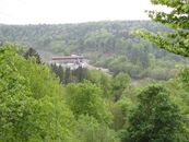
| München, Germany | DerFlob, The T-Man | In a forest alongside the Isar river, south of Grünwald near München |
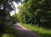
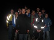
| Surrey, British Columbia | thepiguy, Rhonda, Robyn, Wade, Xore, yangman, Arbron, srs0, Elbie, Kyle, Denise | A short bushwhack from a logging road between Dewdney Trunk Road and Alouet... |
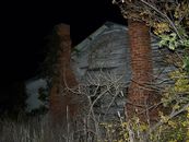
| Vancouver, British Columbia | Someone went | Inaccessible. See the Surrey graticule. The Vancouver location (see right) ... |
| Mannheim, Germany | Koepfel | In Karlsruhe-Grötzingen, next to a sports hall, the Emil-Arheit-Halle |
| Schweinfurt, Germany | Danatar | in a field near Haßfurt. Country: Germany; state: Bayern (Bavaria, EU:DE:B... |
| Berlin, Germany | davidc | At the edge of a field near Baruth (Mark) in the far south of the graticule... |
| Dawson Creek, British Columbia | Air384 | located in a forest. |
| Gävle, Sweden | Jonatan, Ulf | This hashpedition was of a very spontaneous nature. I got the idea when I a... |