2010-06-02 48 9
| Wed 2 Jun 2010 in 48,9: 48.9612051, 9.0297915 geohashing.info google osm bing/os kml crox |
Location
In a field just outside of Sersheim, close to the Westbahn, a railway line from Bruchsal to Bietigheim-Bissingen.
Participants
Plans
Train to Vaihingen (Enz), from there by bike. Sersheim itself has a station, too, in very close walking distance to the hashpoint, but as my student ticket is only valid to Vaihingen, I'd have to buy an extra ticket. Also, some of the trains are so-called Interregioexpress trains (very fast local trains), that use the high-speed line between Vaihingen and Stuttgart and go past Sersheim, e.g. the train I used on the way there was such a train.
Expedition Report
Koepfel
I was at the unicersity during the morning and, after lunch, loaded my bike into a S5 to Durlach, from where I took the 14:09 Interregioexpress to Stuttgart. I arrived in Vaihingen about 30 minutes later.
My next stop was the platform of the so called Vaihinger Stadtbahn. The railway lines around Vaihingen have an interesting history. Here's a map, to follow, black lines are currently used rails, grey are abandoned. On this map, today's hashpoint is located where the railway line leaves the map on the upper right cornder. When the Westbahn was orgininally opened, it want past the town of Vaihingen. So a branch line was build, connecting the towns Vahingen and Enzweihingen to the main line station near Kleinglattbach. When the high speed line was opened in 1991, the Westbahn was rerouted as well, with a station closer to Vaihingen. The branch line was used mainly for school traffic until 2002, then it was closed, yet the tracks are still there.
I left the station northwards and noticed that biking (even pushing the bike) seemed unusually hard. I checked the tires, reinflated them a bit and it went a little bit better. Later back in Karlsruhe, I found out that a spring on my front brake was loose so that another spring was pushing the brake against the wheel. Basically, I did this expedition breaking the entire time.
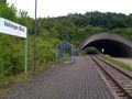
I biked through Kleinglattbach, then stopping at the station Vaihingen Nord (North). This is where the branch line used to join the Westbahn main line, since 1991 it was the terminus of the branch line, today unused.
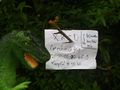
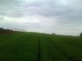
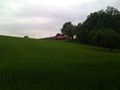
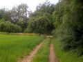
From there, I drove to the next village, which already was Sersheim. I went through the village, past the station and entered some newly built residental area, I drove through that as well and found myself on a field path right next to the Westbahn rail line, with the hashpoint in the field on the other side. 90° happened, I turned into another field path, parked my bike, found a tractor path to walk in and entered the field and found the hashpoint quickly at about 15:30.
The rail line was less than 100 meters away, several trains (a few Stadtbahn trains from Karlsruhe, a Regionalexpress and some freight trains) drove by during my stay. As I wanted to have a train in my obligatory 360° video, I checked the schedules and found out, that the Regionalexpress to Karlsruhe would drive by soon. So I prepared the marker and the camera. And here is the video.
After taking some more pictures, I checked the schedule again, this time for a train home. At about 15:50, I left again and biked back to Vaihingen.
By 16:20, I was back at the Vaihingen station, just in time for a S5 back to Karlsruhe. Contrary to the Interregioexpress, this train stops at every little station and takes about twice as long as the express train, however, the S5 is a dual-system train, going into the tram network in Karlsruhe, so I didn't have to change trains again. At 17:30, I was back in Karlsruhe.
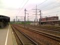
New station of Vaihingen
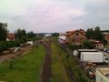
Lower platform at Vaihingen station, unused for 8 years
Also unused station Vaihingen Nord (North)
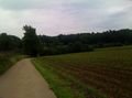
Near the hashpoint
In the field
Train runs by


