2010-06-10 49 8
| Thu 10 Jun 2010 in 49,8: 49.1830694, 8.7989760 geohashing.info google osm bing/os kml crox |
Location
In the forest above Tiefenbach, a part of the town of Östringen.
Participants
Plans
Stadtbahn S31 to Odenheim, bus 134 from there to Tiefenbach West.
Expedition Report
Koepfel
I looked up the coordinates on the day before, seemed reachable, didn't have anything else do to in the afternoon, so I went. After being at the university, I left from Kronenplatz at 14:00 to Durlach and cought a S31 north to Odenheim. Until 1975, the rail line continued to Tiefenbach, these days one has to use a bus, so I entered bus 134 for the remaining kilometers to Tiefenbach.
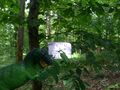
From the bus stop, I went uphill, left the village again and went aqlong one some forest path. Like most days in June, the temperature was around 35°C or more, walking in the very humid forest wasn't very enjoyable. The hashpoint was located pretty much at the path, during the one kilometer I had to walk on it, the GPS pointed forwards. I reached the spot at about 15:30.
As usual, I wrote a marker, took some photos and a video. I didn't stay long both due to the high temperature and due to the fact that I intended to take the 16:12 bus back. Before I left, I scratchted 'XKCD' in the gravel path, then went back to the village.
In Tiefenbach, I walked along the former rail line, which now has been converted into a bike path. At 16:12, I entered the bus back home, changed into a S31 in Odenheim and arrived back in Karlsruhe by 17:20.
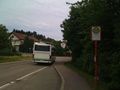
Arriving in Tiefenbach
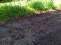
XKCD


Since Tiefenbach (lit: deep creek) is such a generic name (see wikipedia's disambiguation page, I decided to issue a Tale of two hashes challenge.
