2010-07-14 55 10
| Wed 14 Jul 2010 in Odense: 55.1695828, 10.6342099 geohashing.info google osm bing/os kml crox |
About
This time, I brought a friend! We failed though, it was in private property, and the time was 23:59 when we got to the house, so we didn't have time to ask the people who lived there permission to enter.
Participants
Expedition
We sat at Bird's place, wondering what to do with the day, and out of the blue one of us suggested that we check the Geohash coordinates for the day. The place was over 40 km away, the clock was showing 6:15 PM and we had done no preparations whatsoever.
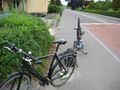
But what the hell, we went for it. Two packed lunchboxes, two bottles of water, a printout of the direction we were supposed to be going, and a Google Maps prinout of the hashpoint and the area surrounding it (we are too poor for a GPS) stuffed into Bird's bag, and we were on our way. After some 10-15 km where we saw some sheep, some cows and stumbled across a container of animal droppings with a sign on it warning us of the "lethal gasses" contained within, we found a gas station and took a little break.
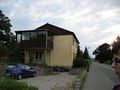
Immediately after getting back on the bikes, Philip's chain went off the gears. This was to be a recurring event. After some trouble, he managed to put it back on, and luckily there was a house nearby, with some very nice people who let him come in and wash his hands. A bit later we saw more animals! A duck, and also a cat, which unfortunately ran away before we could get a picture of Philip thumbs-up-ing next to it.
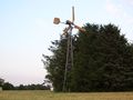
A few kilometers after that, we found an ancient, non-functioning windmill! We (rather, Bird) spent some time climbing it and taking pictures, those are in the gallery below.
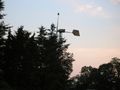
Most of the rest of the trip proceeded pretty uneventfully: we did some geotrashing on the way, and got lost a few times thanks to Google Maps, including at one point ending up on a private road which was simultaneously a dead end, instead of the path at the end that GM had told us would be there. Then when we were roughly 5 km from the spot, and only had 45 minutes left until midnight, Google Maps screwed us again, and we couldn't find the road we were supposed to take. We cycled back and forth for about 10 minutes, and then Bird realized he had an iPod Touch in his pocket - we instantly checked for any unsecured wi-fi, and lo and behold, there was a network within range right where we stood. After some fiddling with the built-in Maps app, we found an alternate route, and hauled ass towards the hashpoint. We finally came within 100m of it... and were met with this. For all you non-Danish speakers out there, it means "Private area: No access".
Defeated, we sat down, ate the rest of our lunchboxes, had a cigarette each, and then started the long, long journey home. It was 4:30 in the morning when we finally came home, completely drained of energy (we are not as sporty as thepiguy, if you were wondering).
Gallery
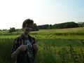
Philip digs the sheep
Philip digs the cows
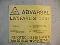
This sign from a container full of animal feces translates into "LETHAL GASSES"
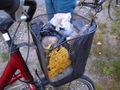
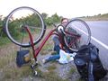
Taking a break from the hard work with some homemade lunch and a beer
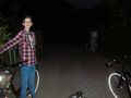
Philip's chain goes off for the first time...
...but luckily the nice people in here let him come in and wash his hands after he's put it back on.

Philip digs the duck

There was a cat here, which Philip would have dug, had it not run away before we could get the picture
Once again, the cat manages to escape before photographic evidence can be procured
Blurry close-up of the windmill
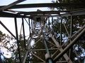
The windmill from the inside!

"Dude, I'm HANGING out on a windmill! Haha!"

"Dude, I know, so am I. It's totally awesome."
It seemed a lot higher up when I was actually up there than the picture makes it look like

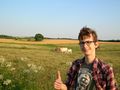
Philip digs the horse (thumbs-up not included)
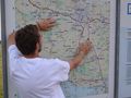
We found a huge map at the side of the road! Left index finger points at our starting point, right one at our current position (this is a bit past halfway)
Doing a bit of geotrashing on the way...
...and Philip's chain goes off for the 4th or 5th time (we stopped counting)
Google Maps, ladies and gentlemen! This is a private road, and also a dead end.


Achievements
WanderingStick earned the No trespassing consolation prize
|
Bird and WanderingStick earned the GeoTrash Geohash Achievement
|
(It was on the way there rather than on the actual hashmark, but the IRC channel seemed to agree it counts)