2010-09-09 30 -94
| Thu 9 Sep 2010 in 30,-94: 30.0347876, -94.6279388 geohashing.info google osm bing/os kml crox |
Location
Several steps south of US-90 near Devers, Texas. I've traveled US-90 from east to west through this area several times. The highway runs through an area comprised mostly of open ranch land, and a few small towns.
Participants
- Phineas
- Ralph (The Naughty Bear)
Plans
This being my first geohash, I was excited to see the hashpoint just a few steps, maybe yards, off a mostly 2-lane highway with which I was rather familiar. Though not my home graticule, this hashpoint was only about 30 miles away, owing to living fairly near the 4-corners of four graticules. Also, I would be returning later in the day from a meeting due south of home, so it was a fairly minor detour.
Scanning the topography and satellite image, the location was clearly in some sort of brushy / woodsy area. But it was so close to the highway, that I thought I could make it without trouble. That general area is mostly ranchland, with a narrow thicket of trees running parallel to the highway. I will admit, it being my first expedition, that my excitement overcame logic when looking at the satellite view of the foliage.
Preparations:
1) TomTom GPS. Though designed for driving directions, it allows 6 decimal place long/lat entry.
2) Hiking Boots
3) Work gloves - for rusty or barbed wire fence scaling, if needed
4) Camera
5) Tripod (to take picture of self and Ralph at site)
6) Color hardcopy of satellite image.....which every time I looked at it, the foliage became more intimidating, possibly. Nah - it's fine.
Expedition
This being my first expedition, there was a considerable and continuous build up of excitement, from the moment I realized that the first geohash I ever pursued was within my reach, to the planning (not enough), to the journey itself. To reach a random spot. Yes. This avocation is indeed well suited to my disposition.
There was also serendipity. The closest town to the hash was Devers, TX. Each time I have passed through Devers (three) or seen Devers on a map (more than three), I think of January 1st, 1986. A few friends and I awoke in a Lake Shore Drive (Chicago) condo after a long night of partying. Eastward in the blinding sunlight, which was magnified by our hangovers, was a...a....a....what is THAT? It was an isolated brick structure quite a way offshore. It wasn't a lighthouse. If one looked further south, there seemed to be another structure about the same distance offshore. What ARE those things? And what is the one we were staring at.
Pre-internet, it took a little longer than it would today to determine "What the hell is that?". That, my new friends, was the William E. Dever Crib, a pumping station used by the City of Chicago. Once we knew that, Bill Dever's crib was a frequent reference to our crowd during late night partying. There even was a short song, something about "Bill Dever....he'll never leave her....".
Since one doesn't encounter all too many Dever's (Deverses?) in their lives, especially ones that have accompanying calendar attributions, I took this as a sign. A sign that I was destined to be a geohasher.
Shortly after departing my clients office, about 30 miles from the hashpoint, I lowered the top on my roadster and cranked up the air conditioning. After all I was in long pants, on a 95 degree day, 70% humidty, 72 dewpoint, bright blazing sun. I've never travelled on US-90 eastbound. Weird. And, to get to the familiar stretch near Devers, I traversed the section between Houston and Dayton for the first time.
With warm winds whipping around me, I approached Dayton, TX, a town I've passed through a number of times....always approaching from different directions. It didn't look familiar at all. I even passed SH-321, my normal east-to-north turn, without recognizing it. Clearly due the excitement of this journey.
Near Liberty, TX I stopped and snapped a photo of the town entrance sign, with a rusted railway bridge over the Trinity River in the background. I considered a stop at BJ's seafood to pick up their advertised crayfish, but with no cooler (note to self), I expected even triple bagged seafood on ice wouldn't survive. Though, a quick stop at a farm stand yielded huge local tomatoes and a jar of hot pickled Okra of questionable age.
On toward Ames and Devers, TX - the two towns that bracketed the hashpoint. As my Tom-tom displayed less than a mile left, I literally felt my heart quicken. I play competitive golf at a moderately high local level, and have trained myself to actively create physical calm while under pressure. Yet, as I approached a random geographic location, I allowed myself the luxury of a recognizable adrenaline rush.
The hashpoint was tens of yards south of the highway, so I knew my GPS would never fully recognized the destination from the road. As I approached the correct longitude, I slowed, and spied TWO HUGE AMERICAN FLAGS at streetside just ahead of me. Thinking, "This geohashing thing is WAY bigger than I thought", I continued forward. To a small abandoned ranch house, with a for sale sign. I was so excited about being able to SEE the hashpoint area, that I neglected to take a picture of said flags, which would have been quite colorful compared to the other photos I'll attempt to include in this write up.
Being able to pull into the driveway, I could orient myself to the correct latitude. I had the geohash in my cross-hairs. And it was....heavily vegetated. Very heavily. I approached from the east, donning the tennis shoes I brought along for the final steps. Hiking boots and a 5-iron would have been better choices.
I returned to the highway, and attempted a north to south entry. Tall grass near the highway, then the dense forested area. After taking ten steps toward the edge of the foliage, I heard a familiar rustle and saw movement in the grass ahead of me. The reason one keeps a 5-iron in hand at all times when searching for golf balls is protection against any of the fifteen species of venomous snakes found in Texas. OK, it could have been a non-venomous snake. Further, it could have been almost any other critter rustling up there. I simultaneously recalled why I rarely hike in Texas and consciously decided not to reach for my camera to prove what was under the grass.
Feeling quite a bit like a frightened junior high school girl, I whirled around and took only about five steps to return to the roadway, half the number it took me to get there. Several seconds of consideration resulted in the decision to not re-enter the treacherous (to me) locale.
Recalling the phrase "Mother Nature's Bitch", I carefully photographed the area, in order to demonstrate said treachery and danger. I had to use my cell phone camera, as I had left my everyday digital cam at home in my haste.
Upon return home, I revisited MNB on the wiki, and was crushed to see the phrase "It is not, for example, sufficient for the Cliffs of Despair award to look at the terrain contours in Google Maps and declare the grade impassable." Crushed, I realized that my probable; no - possible; no - slightly potential snake was not sufficiently daunting (or herpitologous) to claim a consolation prize.
I then recalled a ribbon something along the lines of "Too chicken to proceed". Thusly, I drained my sorrows in vodka.
Wait. I just re-read the MNB definition. It was referring to simply looking at a Google map. It SAYS "To earn these ribbons you must get out there and make the attempt, right up to the point where you cannot go on.". That was ME. I MADE the attempt. Maybe there's hope for me yet. There might not have been alligators, or a swamp, but there was rustling in the Texas tall grass.
I'm torn. I was chicken. AND I was threatened by potentially fatal venomous creatures. I think. I dunno.
I leave it the community to comment. For now....I'm chicken, and looking forward to my next expedition.
Photos
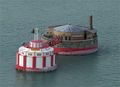
William E. Dever Crib
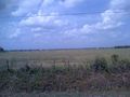
Easily accessible ranch land in the area
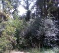
Snake infested hashpoint
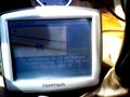
Fuzzy proof of "missing it by that much"
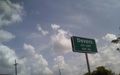
A quick jaunt to the Devers municipal boundary
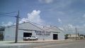
Local color


Achievements
Phineas earned the Prize poultry Consolation Prize
|
- There might be alligators??