2011-12-23 -37 145
| Fri 23 Dec 2011 in -37,145: -37.7899611, 145.0375325 geohashing.info google osm bing/os kml crox |
Location
Kozz - by the looks of things, just north of the Eastern Freeway bike path, about 1km east of the Chandler Highway. Easily accessible by bike. TAlex has already been there so may be able to shed some light when awake.
Participants
- 1:
- 2:
- 3:
Plans
Talex rolled on out there first thing in the morning. Like, literally first thing, in literally the morning. Literally.
Kozz is planning to head there middayish (the -ish bit being the operative word). It looks like it's on the river bank, but from Talex's photos it may be out in the midst of the river? If it's on the golf course...well....things might have to get a bit golfy this afternoon.
Felix Dance dropped in sans Sasha on his way home from Inverloch for the Christmas break. Right on sunset.
Expeditions
#1
tAlex: Night time hash success! No sleep for me tonight.... -- @-37.7900,145.0375 02:05, 23 December 2011 (GMT+10:00)
The full story... I was up late packing to head away for Christmas (with a 5am wake up time...). Over the course of the evening, I lulled my self into a false sense of security and foolishly thought I was organised but at midnight I realised I had to keg and bottle a batch of homebrewed beer. By the time I was finally in bed it was 1:30am, the current Melbourne time when the latest coordinates are released, so for curiosity's sake I thought I'd check the hash point. Under 3km away... Despite the inevitable lack of sleep after a few seconds I gained the will power to haul my self out of bed, got dressed, jumped on my bike and headed to the hash point. Fortunately for me, it's on a bit of path that I know quite well so I rode most of the way without checking my phone. As I got close, I pulled out my phone and started narrowing in. 200m, 100m, 50m, 20, -10m (dammit!), 10m. At this point I parked my bike on the closest tree, turned on my torch and surveyed the towards the hash point and river. Worrying, it looked much less than 10m to the river and I started to prepare my self for a 2am swim. Fortunately, it turned out I need to head diagonally and the hash point was on the lower bank, right next to the river. From here, I attempted (and failed) to take a reasonable photo, updated the wiki from geohash droid and quickly headed back home. I finally climbed into bed at 2:30am, tired but very pleased to make it to a hash point in 30mins from the new coordinates being available :)
#2
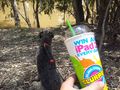
Kozz: My bike's in storage and I am staying just too far away to run there (about 17km round trip according to Google Maps) so I was stuck with the old hydrocarbon burner. Which is fine, because the dog could come along too.
I tried to get in from the Fairfield end of the concrete path, but there's no parking anywhere near it aside from the Guide Dog training place, and I figured they'd get suspicious if I nonchalantly rocked up with a dog and walked off in the other direction, so I went for an explore of the surrounding suburbs to try and find a good entry point. After missing about seven freeway exits and fielding irritated calls from my partner (we were moving house today and I was kinda supposed to meet her at the house - whoopsy) I found a park just 600m from the hashpoint. Straightforward stroll to it; found the hashpoint; as I was taking the photo, Kozz's dog launched himself bodily into the muddy Yarra River which was about 5 metres away. Not impressed. Woolly dog + Yarra river mud = Yarra mud EVERYWHERE.
Anyhoo, I left a hashmarker in organic local materials (tree bark), finished my Squishee Slurpee and rolled on home. Or tried to, at least. Stupid Christmas traffic. I'll upload photos when I can.
#3
Felix Dance: My girlfriend Sasha and I were heading back to Melbourne from my week-time abode of Inverloch, fully intending to do this, supposedly my 50th hash, together. Unfortunately, having faffed around and spent way too much time at the beach we were late for our various evening activities, so I was forced to drop off Sasha at Blackburn while I continued to the hash.
Driving west along the Eastern Freeway almost out of petrol, I hurtled towards the Chandler Highway and thus the hash. Parking on a hill outside the Guide Dogs' Association, I jumped out of the car and jogged the 1.05kms towards the hash. Arriving at the spot extremely sweatily, I took in the amazingness of the hash being right on the bank of the Yarra, just next to the bike path, took a few photos, got bitten by a few mosquitoes and headed back at a relaxed stroll to my car and then my brother's/cousins' Christmas eve party in Carlton. Sadly, not being aware of Kozz's hashmarker, I didn't look for it, and it doesn't seem to have come up on the photos I took.
In the end it turned out to be only my 49th successful geohash. At least I can bring beer to the next one.
Check out the following photos - I used an old technique to create a strange effect with the scenery.
Time of hash: approx. 7:30pm.
Photos
Talex
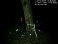
Trusty steed @-37.7900,145.0380
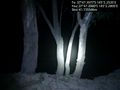
Scenic river views from the hash point, this would be really nice in the day :) @-37.7899,145.0380


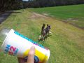
Kozz
Got there!
Kozz's dog takes the lead. Again. In the wrong direction.
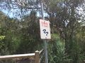
Beware of snakes (a form of raptor) sign
On the hashpoint with
SquisheeSlurpee, and dog that's sitting totally obediently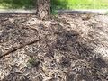
Hashmarker


Felix Dance
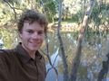
Felix at the hash - upside down... or not?
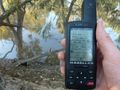
GPS proof with Yarra
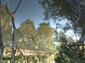
An image... inverted...
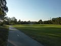
The Hashpark on the Yarra
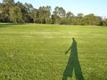
My nonchalant shadow returning from hashing


Achievements
Kozz earned the First Sip GeoSquishy Achievement
|