2012-05-26 49 9
| Have you seen our geohashing marker? We'd love to hear from you! Click here to say "hi" and tell us what you've seen!
Curious about what geohashing is? Read more! |
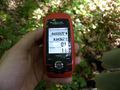
| Sat 26 May 2012 in Würzburg: 49.8302435, 9.9436386 geohashing.info google osm bing/os kml crox |
Location
Today's location is in a forest at the Würzburg city limits.
Country: Germany; state: Bayern (Bavaria, EU:DE:BY); administrative region: Unterfranken; district: Würzburg city district
Weather: Forecast says sunny and up to 22 °C.
Danatar
Planning
How very convenient! The Mouseover Day geohash is very close, and the weather should be very nice. I'm planning for 4 p.m., but haven't decided yet on my mode of transport.
Expedition
I started on foot at 3 p.m. and walked through Würzburg and up the hill to the fields north of the city. From there I just had to follow a straight field track until I was near the hashforest. On the last part, I walked on the small part between two fields to get to that forest, because there were no real tracks. Then I saw a bike and a backpack lying on the side of the track near where the hashpoint should be. I was genuinely surprised. Another person, here at the hashpoint? That could be a geohasher, but who would be geohashing near Würzburg except for myself? Then Gefrierbrand greeted me.
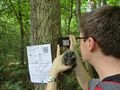
It was 3 minutes to meetup time, so we walked the last metres to the hashpoint. Our GPS units indicated different locations, but I finally got a picture showing the correct coordinates. While I took a picture of Scott at the hashpoint, Gefrierbrand went to get his hashpoint marker and affixed it to a tree visible from the track. We talked a bit and shared some Canadian geohashing food specialty, before returning.
I had originally planned to do this expedition on a tron route, but the surprise of another geohasher distracted me from my GPS unit and my route crossed itself near the hashpoint. So I took almost the same route as before on my way back.
In total, I walked 9.8 km. This is my 150th expedition, and my 50th successful one in the Würzburg graticule.
GPS
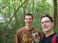
Gefrierbrand and Danatar at the hashpoint
Scott at the hashpoint
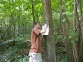
Gefrierbrand affixing the marker
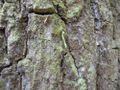
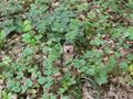
Caterpillar
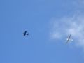
the 4th of 5 gliders being aerotowed during my expedition


tracklog
Gefrierbrand
Planning
Indeed very convenient, I'll try to be there as well. I'm going to go by bike and should be there around 4pm. Time to meet up ;-)
Expedition
On Saturday afternoon, I started biking while heading in the general direction in beautiful weather at around 3pm. Despite having to climb quite steep hills, I made good progress and reached the approximate hash location about 15 minutes prior to the official meet up time. As I entered the forest, the GPS signal strength dropped considerably and I was not able to exactly pinpoint the location. I therefore waited in the general area and used the time to read some quite interesting signboards explaining parts of the forest and its vegetation located not far away. As I returned from this sign, I practically ran into Danatar, who was quite surprised to find someone else geohashing. We then combined our GPS-Powers and were able to get to the hashpoint within the margin of error. I put up a marker for other potential new geohashers close tho the actual location facing the forest track for best possible perceptibility. We then shared celebratory candy for the special occasion before returning home again.
Gallery
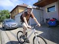
Starting at home, including Silly Grin
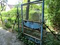
I found an old rusty door about 1 km from the hash
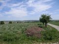
Reward for cycling uphill: view over Würzburgs outskirts
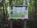
Sign with information about the common spruce
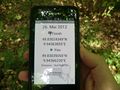
Location reached. (The margin of error was bigger than the displayed 5 m)
Picture of Danatar taking a picture of some caterpillar including Hashscot and Geohashing-Marker


Achievements
Gefrierbrand earned the Land geohash achievement
|
Gefrierbrand earned the Bicycle geohash achievement
|
Gefrierbrand and Danatar earned the 2012 Mouse Over Day achievement
|
Gefrierbrand earned the Meet-up achievement
|
Gefrierbrand earned the Earliest geohasher achievement
|