Difference between revisions of "2012-08-17 51 5"
imported>Marvyn |
imported>Marvyn |
||
| Line 52: | Line 52: | ||
| latitude = 51 | | latitude = 51 | ||
| longitude = 5 | | longitude = 5 | ||
| − | | date = | + | | date = 2012-08-17 |
| name = Marvyn | | name = Marvyn | ||
| Line 68: | Line 68: | ||
| latitude = 51 | | latitude = 51 | ||
| longitude = 5 | | longitude = 5 | ||
| − | | date = | + | | date = 2012-08-17 |
| granter = a nice lady | | granter = a nice lady | ||
| name = Marvyn | | name = Marvyn | ||
Revision as of 00:28, 22 August 2012
| Fri 17 Aug 2012 in 51,5: 51.9729283, 5.1433848 geohashing.info google osm bing/os kml crox |
Location
Under something with a roof, next to a farm and a couple of big white vehicles on the 'dry' side of a dike following the river Lek.
Participants
Plans
An ad-hoc expedition, dragging along my girlfriend Iris when we found ourselves stuck in a boring town with a few extra hours on our hands.
Expedition
After a weekend in the eastern part of the country, my girlfriend and I drove around in the area for a bit before going home again. Around noon we decided that the town we were visiting had practically nothing to offer, so I suggested to look on her smartphone for any reachable geohashes along our route back home. There was one not too far out of our route and as we wanted to visit something anyway, the fuel was spent well rather than wasted.
The hash appeared to be in a building or shed of some sort, probably on private property. A few large white vehicles, probably trucks, were parked nearby. We didn't know if the hash would be reachable, but decided in front that we would settle for a consolation price if it was necessary.
After a nice drive, we left the highway and after a while we drove up a dike. Driving there was quite tricky, considering the fact that I don't drive much, every driver coming toward us almost pushed us off the road and down the slope and that we had to navigate at the same time. Iris used her smart phone to find the adress. After a while we passed a farmhouse which was also a place for camper storage and we both screamed: 'It's here!'. Excitedly, I parked the car on a steep exit from the dike and armed with my camera and my hashcot Pollo we walked back to the farmhouse.
With more guts than I thought I had I rang the bell and waited for someone to come, because although there weren't any signs, the hash was obviously on private property. At last, someone came out the back and I had to improvise a good story to get ambassador acces to the property. Explaining geohashing to the woman was rather difficult (although we weren't surprised about that), but when I promised her that we would only walk a bit further and take a picture without disturbing or touching anything. She seemed afraid that while we were back there, someone would break into the house, but she let us do it anyway.
After having walked a bit further, we checked the GPS and saw that the hash fell exactly in one of her barns. Being so close, we couldn't turn back now. It took all my courage to ask the still very sceptical lady if we could go into the barn and a lot of extra explaining to keep her from shooing us off her land, but in the end she shrugged and allowed us in.
A rush of adrenaline came to us as we realised we were actually inside someone's property, telling them the internet sent us and that we had to go there to score 'points' on a website. We relished in the foolishness of our action. We took our pictures and then left so we would not disturb the woman any further. Because she still didn't really seem to grasp the idea of geohashing, I promised to send her a letter explaining it (which I did). After that, we thanked her and left. We took some more pictures in the vicinity, almost wrecked the car because I couldn't convince it to go uphill (so we kept sliding downward toward another car with every attempt to start it) and left for home, smiling and celebrating.
Photos
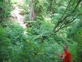
One side of ravine...
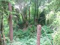
... and the other.
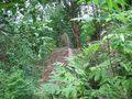
This tree leads towards the spot.
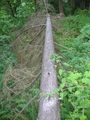
No further for me.


Achievements
Marvyn earned the Land geohash achievement
|
Marvyn achieved level 1 of the Minesweeper Geohash achievement
|
Marvyn earned the Ambassador achievement
|
Marvyn earned the Drag-along achievement
|