2012-09-14 52 1
| Fri 14 Sep 2012 in Norwich: 52.8149674, 1.5140635 geohashing.info google osm bing/os kml crox |
Contents
Location
In the shadow of East Ruston water tower, Norfolk, UK.
Participants
Expedition
Jaydublu: Not a great hardship - this location was 100 yards from the turn around point when I take our dog for his daily walk. It was in the overgrown margin of a potato field, under East Ruston water tower near Happisburgh on the North Norfolk coast. The weather was 'autumnal' with a fresh breeze, and being one of the highest locations for many, many miles the view was wonderful.
Sourcerer: Neil took a wandering route home from work and parked in the water tower access lane. The field corner had been planted with clover and seed flowers to encourage birds and bees. There was a fairly obvious tack from the field access through the clover which ended right at the hashpoint. Clearly a ninja hasher had already visited! Of course it was the track left by Jaydublu + dog. Neil says Hi and believes this is the first ever Norwich hashpoint to be visited by more than one geohasher. It's getting crowded here!
Photos
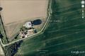
Google Earth View
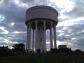
East Ruston water tower
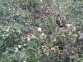
The clover and other wild flowers


Expeditions and Plans
| 2012-09-14 | ||
|---|---|---|
| Norwich, United Kingdom | Jaydublu, Sourcerer | In the shadow of East Ruston water tower, Norfolk, UK. |
| Malmö, Sweden | Llavids | Rolsberga, Höör, Skåne, Sweden. |
| Moscow, Russia | vb | Railway tracks between Krasniy Baltiets and Leningradskaya stations. |
Sourcerer's Expedition Links
2012-09-02 52 0 - 2012-09-14 52 1 - 2012-09-28 52 1 - KML file download of Sourcerer's expeditions for use with Google Earth.