Difference between revisions of "2014-05-31 55 12"
imported>J0e (Created page with "Coming soon") |
imported>FippeBot m (Location) |
||
| (6 intermediate revisions by one other user not shown) | |||
| Line 1: | Line 1: | ||
| − | + | {{meetup graticule | |
| + | | lat=55 | ||
| + | | lon=12 | ||
| + | | date=2014-05-31 | ||
| + | }} | ||
| + | __NOTOC__ | ||
| + | == Location == | ||
| + | Forest area surrounding Salpetermosen (The Saltpeter Bog) outside Hillerød | ||
| + | |||
| + | == Participants == | ||
| + | *[[User:j0e|j0e]] | ||
| + | |||
| + | == Expedition == | ||
| + | [[File:2014-05-31_55_12_expedition_DZ1A7466_1024px.jpg|300px|thumb|left|The evidence. Yup, still using "Old Yeller"]] | ||
| + | |||
| + | [[User:j0e|j0e]] finally got tired of hiding in his apartment and went out of hibernation. The area was a patch of nature not far from Hillerød a 20 minute walk from the station. The weather was near perfect for this sort of thing: Cloudy with a some sun here and there, a little windy and not too warm. | ||
| + | |||
| + | I left a marker near the geohash. The material is rather lightweight and it's a bit windy today, so if you want to go find it, please hurry ;-) | ||
| + | |||
| + | After having visited the spot I found some logs a couple of hundred meters away, where I could sit and have lunch. After lunch I edited this page. | ||
| + | |||
| + | I didn't meet any other geohashers which isn't surprising given the relativly low level of activity in [[København,_Denmark|55 12]]. | ||
| + | [[File:2014-05-31_55_12_expedition_DZ1A7468_1024px.jpg|300px|thumb|right|Marker.]] | ||
| + | |||
| + | Edited on location by [[User:j0e|j0e]]. | ||
| + | |||
| + | == Important notice == | ||
| + | |||
| + | After having visited the geohash, I decided to have a further look at Salpetermosen. I walked further down the road, and found an access road to another of the many ponds in the area. I met a gentleman there who kindly informed me that all of Salpetermosen is PRIVATE PROPERTY! Not easy to guess since there were neither fences nor signs of any kind to hint that it is. To further add to the confusion the page about the area on [http://www.fugleognatur.dk/lokalitetintro.aspx?ID=16543 www.fugleognatur.dk] (birds and nature page in Danish) does not mention this fact either. | ||
| + | |||
| + | All further expeditions to this area (as if...) are discouraged. | ||
| + | |||
| + | == Additional photos == | ||
| + | |||
| + | <gallery> | ||
| + | Image:2014-05-31_55_12_expedition_DZ1A7464_1024px.jpg | Additional evidence. "Old Yeller" isn't the most accurate thing in the world. | ||
| + | Image:2014-05-31_55_12_expedition_DZ1A7474_1024px.jpg | Nettles, nettles everywhere. | ||
| + | Image:2014-05-31_55_12_expedition_DZ1A7479_1024px.jpg | A nice pond near the geohash. | ||
| + | Image:2014-05-31_55_12_expedition_DZ1A7482_1024px.jpg | Another pond. | ||
| + | |||
| + | </gallery> | ||
| + | |||
| + | == Achievements == | ||
| + | {{#vardefine:ribbonwidth|800px}} | ||
| + | |||
| + | {{land geohash | latitude = 55 | longitude = 12 | date = 2014-05-31 | name = [[User:j0e|j0e]] | image = 2014-05-31_55_12_expedition_DZ1A7466_1024px.jpg | ||
| + | }} | ||
| + | |||
| + | |||
| + | <!-- =============== USEFUL CATEGORIES FOLLOW ================ | ||
| + | Delete the next line ONLY if you have chosen the appropriate categories below. If you are unsure, don't worry. People will read your report and help you with the classification. --> | ||
| + | [[Category:Expeditions]] | ||
| + | [[Category:Expeditions with photos]] | ||
| + | [[Category:Coordinates reached]] | ||
| + | {{location|DK|84}} | ||
Latest revision as of 06:46, 14 August 2019
| Sat 31 May 2014 in 55,12: 55.9179713, 12.3020586 geohashing.info google osm bing/os kml crox |
Location
Forest area surrounding Salpetermosen (The Saltpeter Bog) outside Hillerød
Participants
Expedition

j0e finally got tired of hiding in his apartment and went out of hibernation. The area was a patch of nature not far from Hillerød a 20 minute walk from the station. The weather was near perfect for this sort of thing: Cloudy with a some sun here and there, a little windy and not too warm.
I left a marker near the geohash. The material is rather lightweight and it's a bit windy today, so if you want to go find it, please hurry ;-)
After having visited the spot I found some logs a couple of hundred meters away, where I could sit and have lunch. After lunch I edited this page.
I didn't meet any other geohashers which isn't surprising given the relativly low level of activity in 55 12.

Edited on location by j0e.
Important notice
After having visited the geohash, I decided to have a further look at Salpetermosen. I walked further down the road, and found an access road to another of the many ponds in the area. I met a gentleman there who kindly informed me that all of Salpetermosen is PRIVATE PROPERTY! Not easy to guess since there were neither fences nor signs of any kind to hint that it is. To further add to the confusion the page about the area on www.fugleognatur.dk (birds and nature page in Danish) does not mention this fact either.
All further expeditions to this area (as if...) are discouraged.
Additional photos
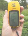
Additional evidence. "Old Yeller" isn't the most accurate thing in the world.
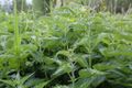
Nettles, nettles everywhere.
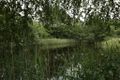
A nice pond near the geohash.
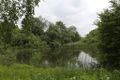
Another pond.


Achievements
j0e earned the Land geohash achievement
|