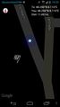
2015-05-16 48 8
| Sat 16 May 2015 in 48,8: 48.2901765, 8.1095283 geohashing.info google osm bing/os kml crox |
Location
In Fischerbach, a little village near a main route I often take.
Participants
- Max,
- RCs parents and
- RecentlyChanged himself.
Plans
First plan: We drive from Karlsruhe over Offenburg to the hash and then further to Villingen-Schwenningen. RC will introduce two new girls to geohashing!
Just something that made me really happy: I just showed the map from hashdroid with the little flag to Max without telling him what it was. Only thing he said, while taking the smartphone and starting to zoom out, 'Where's the hash located?'.
Expedition
First attempt
I quickly averted the first plan on accident. I sat in the back of the car we had to make our way from Karlsruhe to Villingen-Schwenningen. Because I usually drive myself I didn't really see where we were and gave the advice to take the right lane at the wrong moment. It wasn't that bad in terms of getting to Villingen Schwenningen (we only lost about 10 minutes according to the GPS device) but we would not be near the hashpoint at all and so I lost the opportunity to introduce two new hashers.
Second attempt
We take the motorbikes and visit the hash.
Luckily we had nothing big planned that day, so we made a big tour on the motorbikes. Max, my parents and I were attending and it was great, except that I had to ride at the front of our group and felt watched the whole time. Still we made a great tour. To my delight my parents were with us the whole route, even though they thought about leaving us earlier.
At Fischerbach we stopped to look up the hashpoint and decided to walk the rest of the way. It was a really calm and nice little village, old people where walking around and we talked to them a little bit: a nice woman was gardening and a big flock of boys around 10 years where running around with two walkie-talkies and a few of them just with socks. It was almost idyllic.
Because I ran low on battery after I supplied the music half of the time from Karlsruhe home, and we had a long ride, and the battery is always running low when Max is around, I just took a few pictures at the hashpoint and one of our bikes. We went home over the Landwassereck, which is an awesome route on motorbike. There my bike almost threw me off, because I underestimated a turn in the road, but that is another story.
Photos
Proof
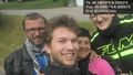
The hashers!
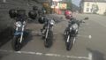
Our nice bikes!


Achievements
Max, RCs parents and RecentlyChanged earned the Land geohash achievement
|
