Difference between revisions of "2015-06-28 48 8"
imported>RecentlyChanged ([retro picture] My sisters in front of the hash car.) |
imported>FippeBot m (Location) |
||
| (8 intermediate revisions by one other user not shown) | |||
| Line 22: | Line 22: | ||
== Participants == | == Participants == | ||
| − | + | *[[User:RecentlyChanged|RecentlyChanged]] ([[User_talk:RecentlyChanged|talk]]) | |
| − | + | *younger sister | |
| − | + | *older sister | |
| − | |||
| − | |||
== Expedition == | == Expedition == | ||
| − | <!-- | + | I wanted to go there the whole day, the weather even opened the possibility to go there with bare feet. <!-- glad I did not do that --> |
| − | + | But for some reasons I had not slept much the night before and had a really bad headache. | |
| − | + | So we only left in the evening to walk part of it. | |
| − | + | Still it was a really nice and beautiful trip because of the weather and my sisters. | |
== Photos == | == Photos == | ||
| − | |||
| − | |||
| − | |||
<gallery perrow="5"> | <gallery perrow="5"> | ||
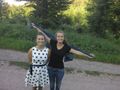
Image:2015-06-28_48_8_RecentlyChanged_1435510880000.jpg | My sisters in front of the hash car. | Image:2015-06-28_48_8_RecentlyChanged_1435510880000.jpg | My sisters in front of the hash car. | ||
| + | |||
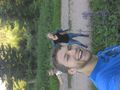
| + | Image:2015-06-28_48_8_RecentlyChanged_1435510891000.jpg | View south from the hashcar | ||
| + | |||
| + | Image:2015-06-28_48_8_RecentlyChanged_1435512389000.jpg | Proof we were on the Brücklerainweg | ||
| + | |||
| + | Image:2015-06-28_48_8_RecentlyChanged_1435513097000.jpg | View to the undisturbed hashpoint | ||
| + | |||
| + | Image:2015-06-28_48_8_RecentlyChanged_1435513166000.jpg | View from the hashpoint | ||
| + | |||
| + | Image:2015-06-28_48_8_RecentlyChanged_1435513171000.jpg | Stupid | ||
| + | |||
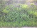
| + | Image:2015-06-28_48_8_RecentlyChanged_1435513215000.jpg | The disturbance! We already made it to the hash staying on the street (according to hashdroid). But resulting from a discussion I had a few days ago in #geohashing I had to go into the high grass. Because it made a difference. | ||
</gallery> | </gallery> | ||
== Achievements == | == Achievements == | ||
{{#vardefine:ribbonwidth|800px}} | {{#vardefine:ribbonwidth|800px}} | ||
| − | + | {{land geohash | |
| − | + | | latitude = 48 | |
| − | + | | longitude = 8 | |
| − | + | | date = 2015-06-28 | |
| − | + | | name = All participants | |
| − | + | }} | |
| − | + | {{Two to the N achievement | |
| − | + | | count = 1 | |
| − | + | | date = 2015-06-28 | |
| − | + | | latitude = 48 | |
| + | | longitude = 8 | ||
| + | | name = RCs older sis | ||
| + | | reached = true | ||
| + | }} | ||
| − | |||
[[Category:Expeditions]] | [[Category:Expeditions]] | ||
| − | |||
[[Category:Expeditions with photos]] | [[Category:Expeditions with photos]] | ||
[[Category:Expeditions with videos]] | [[Category:Expeditions with videos]] | ||
| − | |||
| − | |||
| − | |||
| − | |||
[[Category:Coordinates reached]] | [[Category:Coordinates reached]] | ||
| − | + | {{location|DE|BW|VS}} | |
| − | |||
| − | |||
| − | |||
| − | |||
| − | |||
| − | |||
| − | |||
| − | |||
| − | |||
| − | |||
| − | |||
| − | |||
| − | |||
| − | |||
| − | |||
| − | |||
| − | |||
Latest revision as of 04:10, 15 August 2019
| Sun 28 Jun 2015 in 48,8: 48.1041680, 8.1525844 geohashing.info google osm bing/os kml crox |
Location
Briglerain/Brücklerain? On the side of a hill
Participants
- RecentlyChanged (talk)
- younger sister
- older sister
Expedition
I wanted to go there the whole day, the weather even opened the possibility to go there with bare feet. But for some reasons I had not slept much the night before and had a really bad headache. So we only left in the evening to walk part of it. Still it was a really nice and beautiful trip because of the weather and my sisters.
Photos
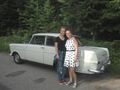
My sisters in front of the hash car.
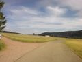
View south from the hashcar
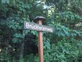
Proof we were on the Brücklerainweg
View to the undisturbed hashpoint
View from the hashpoint
Stupid
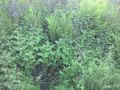
The disturbance! We already made it to the hash staying on the street (according to hashdroid). But resulting from a discussion I had a few days ago in #geohashing I had to go into the high grass. Because it made a difference.


Achievements
All participants earned the Land geohash achievement
|
