2015-07-24 52 1
| Fri 24 Jul 2015 in Norwich, UK: 52.4272551, 1.6928650 geohashing.info google osm bing/os kml crox |
Location
In a field west of Kessingland, Suffolk, UK.
Participants
Plans
Expedition one of two spanning midnight - 2015-07-24 52 1 - 2015-07-25 52 0 - ETA 22:35
Expedition
- Arrived. -- Sourcerer (talk) @52.4273,1.6926 22:28, 24 July 2015 (GMT+01:00)
I stocked up with food on the way to this geohash. It was raining hard by English standards and there were minor floods requiring careful driving. The nearby town of Beccles made it onto the national news for breaking a rainfall record. No roads were completely blocked though. At the destination there were nice clear tractor tracks and the log below shows my attempt to zero the distance. This was slightly harder than usual. Managing a wind blown umbrella, a GPS receiver and a smart phone really needs three hands. The track log shows me getting closer than the evidence photo suggests. I got quite damp and muddy but not enough for a drowned rat achievement.
Photos
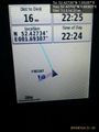
Proof. @52.4273,1.6930
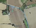
Track in Google Earth


Expeditions and Plans
| 2015-07-24 | ||
|---|---|---|
| Darwin, Australia | Felix, Lucy, Pinto | In the mangroves on the western side of Darwin Harbour, near Mandorah. |
| Payette, Idaho | Eldin | Along US-30, just east of the Oregon border. |
| Kassel, Germany | GeorgDerReisende | The hash lay in the forest above Hann. Münden. |
| Norwich, United Kingdom | Sourcerer | In a field west of Kessingland, Suffolk, UK. |
| Hannover, Germany | Fippe | located on a field in Hannover-Vinnhorst near the Mittelland Canal. |
| Malmö, Sweden | Fasanen | Narrow strip between a tree alley and a rape field Charlottenlund, Ystad, S... |
| Skövde, Sweden | cjk | Somewhere |
| Tampere, Finland | Pastori, The Wife | In Pirkkala, Tampere. The point lies on a cross-country skiing track. |
| Rovaniemi, Finland | isopekka | In Rovaniemi, in Tavivaara graveyard. |
Sourcerer's Expedition Links
2015-07-22 52 1 - 2015-07-24 52 1 - 2015-07-25 52 0 - KML file download of Sourcerer's expeditions for use with Google Earth.