2016-05-20 42 -78
| Fri 20 May 2016 in 42,-78: 42.0753931, -78.7656838 geohashing.info google osm bing/os kml crox |
Location
Allegany State Park, in the Red House area
Participants
- Pedalpusher
- Simon the dog
- Myka the dog
Expedition
I like when the hashes land in Allegany State Park so the plan was to drive down after work and hike to the hash. I saw from a park map that the hash was close to where the Conservation trail and the Finger Lakes/North Country Trail meet. I've had trouble finding the Conservation trail from behind the Admin building so I drove to where the North Country trail crosses the ASP 1 Road and parked at that trailhead. It was a nice walk in but with the curving trail, I had to figure out when to cut into the woods. I finally got to within a quarter mile and thought that was the closest the trail was going to get. I started wandering into the woods trying to follow the GPS but pretty much right away, I had a feeling things were going to get difficult.
As I was working my way to the hash, the GPS would indicate I need to veer about 45 degrees to the right. I would sort of turn that way and suddenly, it would say I now have to veer about 45 degrees to the left. After zig-zagging like this for a while, I decided to just walk straight and figure it out when I got closer. At least at this point, the distance was still going down.
Getting within 100 feet/30 meters, I got my phone ready to take a picture. I got into an area with a bunch of pine trees and was down to within 2 feet but my phone turned off. By the time I got the phone ready to take a picture again, the GPS had jumped up to over 20 feet to go. I started wandering around and had the most infuriating GPS dance EVER! It said to go East but when I started moving, pointed west...and the distance was slowly rising. So I turned around and...the distance kept rising...and the GPS still pointed behind me. I got up to about 50 feet to go and then got it down to about 20 feet to go before repeating this about 5 times. AGH! Finally I decided to just walk out the way I came until it read 100 feet to go and tried walking in again. Fail! Still couldn't get it to read less than 20 feet. Trying to walk away and walk back in again was finally sort of successful getting a reading of about 4 feet to go. Finally getting some pictures, we headed back to the trail.
I'm sure we were all starving by the time we got home at 21:00. I fed the dogs right away and threw my pizza in the oven to start cooking. I made the dough before we left and it had risen nicely.
Photos
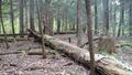
I walked all over, under these pines...
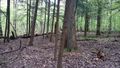
...trying to get a good reading.
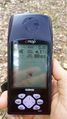
The best I could get.
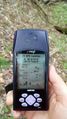
Which was weird because the accuracy looked pretty high.
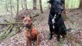
The dogs sitting nicely at the hash with their own goofy grins.

Just happy to be done with the stupid GPS dance.


Ribbons
This user earned the Land geohash achievement
|