Difference between revisions of "2016-08-10 42 -78"
imported>FippeBot m (Location) |
Pedalpusher (talk | contribs) m (→Photos: adjusted grid) |
||
| Line 21: | Line 21: | ||
== Photos == | == Photos == | ||
| − | <gallery perrow=" | + | <gallery perrow="7"> |
Image: 2016-08-10 roadClosed.jpg | Detour signs everywhere due to (assumed) bridge work. | Image: 2016-08-10 roadClosed.jpg | Detour signs everywhere due to (assumed) bridge work. | ||
Image: 2016-08-10 closed.jpg | Another road closure close to the hash. | Image: 2016-08-10 closed.jpg | Another road closure close to the hash. | ||
| Line 29: | Line 29: | ||
Image: 2016-08-10 parked.jpg | View back to the car. | Image: 2016-08-10 parked.jpg | View back to the car. | ||
Image: 2016-08-10 stupidGrin.jpg | Stupid grin. | Image: 2016-08-10 stupidGrin.jpg | Stupid grin. | ||
| − | </gallery> | + | </gallery> |
== Ribbons == | == Ribbons == | ||
Latest revision as of 00:57, 2 April 2020
| Wed 10 Aug 2016 in 42,-78: 42.4303113, -78.8371269 geohashing.info google osm bing/os kml crox |
Location
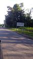
On the edge of N Otto Rd, by Zoar Valley
Participants
Expedition
My 100th expedition! Woo!
Attempting another consecutive hash that appears to be on the shoulder of the road and not to hard to get to...haha...yeah...so many detours.
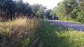
So I have my directions written out and I found on the map that the East Otto State Forest is right around the corner. I figure I can take the dogs for a hike after the hash and make a random drive worth it. Getting nearly there, I found signs that the road I'm looking for (N. Otto Rd) is closed. I know there is a bridge over Cattaraugus Creek and that must be what they are working on. I started to follow the detours and the next bridge over the creek is a long way off. Had I known how far off, I would have looked at a map to get to Rt 219 but, alas, I did not.
I followed the detour along the creek to the North into Gowanda where I crossed and followed it back along the south eventually to N. Otto Rd. However, there were still signs for the detour for N. Otto Rd. and I passed a road block sign saying road closed 6 miles ahead. That's ok, I only have to go 5 miles. Thinking nothing of it, with about a half mile to go, I see another sign saying Road closed 1/4 mile ahead. What? Did I just take a 40 minute detour to end up on the wrong side of the block?
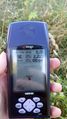
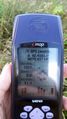
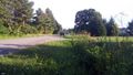
I again followed the detour but this one was only around the block as there was probably a wash-out where the road dipped. Finally getting to the hash after almost an hour and a half of driving, I hopped out of the car and walked to the edge of the property where the hash was. I was able to get a successful reading and even though there was No Trespassing signs, they started on the top of the three foot incline next to the road and the hash was just in front of that, kind of in the sort-of-ditch. Success had, we went around the block again and made our way to the State Forest for a much shorter hike than originally planned.
Needless to say, we went home a different way and got there MUCH faster.
Photos
Detour signs everywhere due to (assumed) bridge work.
Another road closure close to the hash.
Finally made it!
Accuracy.
View North and you can see how close this was to No Trespassing.
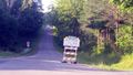
View back to the car.

Stupid grin.


Ribbons
This user earned the Land geohash achievement
|
Pedalpusher earned the Consecutive geohash achievement
|