2017-02-13 52 1
From Geohashing
Revision as of 02:08, 16 August 2019 by imported>FippeBot (Location)
| Mon 13 Feb 2017 in Norwich, UK: 52.4975356, 1.2885181 geohashing.info google osm bing/os kml crox |
Location
A field between Hempnall and Fritton, Norfolk, UK.
Participants
Plans
Two of two spanning midnight 2017-02-12 52 1 - 2017-02-13 52 1 - ETA 00:00.
Expedition
There was a place to park beside some barns. A public footpath led off but there was a more convenient field entrance and farm track. This led close but there was a 60 metre trek through sinking mud in the freshly ploughed field. It could have been worse. Sometimes there's standing water in the mud troughs. Today it was damp but not awash.
Photos
- Gallery
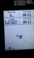
Arrived. @52.4976,1.2885
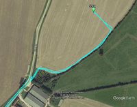
Google Earth Track


Achievements
Sourcerer earned the Midnight Geohash achievement
|
Expeditions and Plans
| 2017-02-13 | ||
|---|---|---|
| Norwich, United Kingdom | Sourcerer | A field between Hempnall and Fritton, Norfolk, UK. |
Sourcerer's Expedition Links
2017-02-12 52 1 - 2017-02-13 52 1 - 2017-02-26 52 1 - KML file download of Sourcerer's expeditions for use with Google Earth.