Difference between revisions of "2017-04-03 51 7"
imported>FippeBot m (Location) |
m |
||
| Line 69: | Line 69: | ||
<!-- Add any achievement ribbons you earned below, or remove this section --> | <!-- Add any achievement ribbons you earned below, or remove this section --> | ||
| + | [[Category:Expeditions]] | ||
[[Category:Expeditions with photos]] | [[Category:Expeditions with photos]] | ||
[[Category:Coordinates reached]] | [[Category:Coordinates reached]] | ||
{{location|DE|NW|BO}} | {{location|DE|NW|BO}} | ||
Latest revision as of 11:53, 23 September 2021
| Mon 3 Apr 2017 in 51,7: 51.4625182, 7.3322727 geohashing.info google osm bing/os kml crox |
Location
In a small forest in the town of Bochum.
Participants
Plans
I wanted to go to my university on this day, and saw that I could reach the geohash with just a little detour.
Expedition
I took the train train RE16 to Essen, but I left the train in Witten so I could take the bus 378 to Bochum Langendreer. I did not check the bus stops before my trip, so I just stayed in the bus until I was "close enough" to my geohash point (about 1.5 km away). I was already prepared that this geohash will be laying in a forest, but I was unaware of the "accessibility" of this area. Fortunately, I saw that the area was "protected landscape" and there were several footpaths. Nice! (protected landscape, "Landschaftsschutzgebiet", does not mean that trespassing is not allowed, so no worries). Unfortunately, my GPS was quite messe and unreliable, so it was quite hard to keep track where to go. I went circles on the footpath around my coordinates, and decided that I have to leave the footpath to actually reach the coordinates - I was still about 50 metres away. Here, my problems started, because It was getting harder to go forward and my GPS was not really able to keep track. The best I could get can be seen on the screenshot: The GPS seemed to be ok up until this point, but it did not update after I approached the coordinates. Hopefully this is sufficient as a proof, and everyone will believe that I walked the last 15 meteres to the right direction :-)
As a surprise, there was a "wooden tipi" quite exactly where the coordinated were supposed to be!
Tracklog
Photos
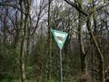
Protected landscape.
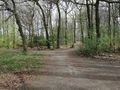
Footpath in a forest in Bochum.
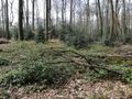
Forest, away from the footpath.
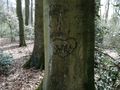
A heart in a tree. Oww!
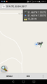
GPS proof - Or rather the best proof I could get.
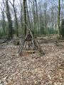
A wooden tipi at my geohash position!


