| Wed 24 May 2017 in 64,24: 64.2331964, 24.4144432 geohashing.info google osm bing/os kml crox |
Location
Alavieska, near the village Riitaniittu in Kunnarinperä. The point lies in an old fir forest.
Participants
- Pastori
- The Wife
Expedition

After a few days of vacationing and hiking in mostly the sea graticule 64 23, where they did not catch a point even though Pastori notoriously loves fishing, Pastori and Wife headed home with the intention to try and conquer two new graticules.
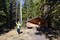
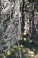
Thanks to superb navigation from Wife they arrived surprisingly close to the first hashpoint within the first hour, at 9:30 am. They were also able to park their car nicely near a new wicket. The point was 400 meters away as the bird flies. So off they went, hiking through the seemingly dry, though a little difficult looking forest in the beautiful early spring sunshine. Within the 400 m to the point there were several different types of forest like swampy forests and a couple of ditches, open areas where the trees had been cut down, rocky pine forests and old-growth fir trees with beard moss growing on them. Surprisingly the swampy forest bed carried them well, so the earth must still be frozen in the forest, though of course the snow has already melted even in these latitudes. They reached the hashpoint with an 0.793 m accuracy. Nicely done in the middle of a thicket of fir trees. They returned to the car happily.
Here are the facts: 33 min 1 second, 1.12 km, average speed 2.1 km/h. On they go to the next hashpoint.


Photos
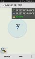
GPS proof.
There it is!


Achievements
Pastori earned the Land geohash achievement
|