Difference between revisions of "2017-12-29 29 -97"
From Geohashing
imported>FippeBot m (Location) |
m |
||
| Line 52: | Line 52: | ||
{{Virgin graticule | latitude = 29 | longitude = -97 | date = 2017-12-29 | name = thunk }} | {{Virgin graticule | latitude = 29 | longitude = -97 | date = 2017-12-29 | name = thunk }} | ||
| + | [[Category:Expeditions]] | ||
[[Category:Expeditions with photos]] | [[Category:Expeditions with photos]] | ||
| − | |||
[[Category:Coordinates reached]] | [[Category:Coordinates reached]] | ||
{{location|US|TX|FT}} | {{location|US|TX|FT}} | ||
Revision as of 12:30, 23 September 2021
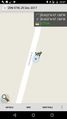
| Fri 29 Dec 2017 in 29,-97: 29.8216998, -97.1377186 geohashing.info google osm bing/os kml crox |
Location
Participants
Plans
Expedition
- Success! The actual hashpoint is probably just on the other side of the barbed wire fence on a ranch but leaning over gets you within the circle. So it counts. -- Thunk (talk) @29.8217,-97.1377 22:40, 29 December 2017 (GMT+00:00)
Tracklog
Photos
Proof
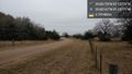
Looking north @29.8217,-97.1377
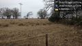
Looking east @29.8216,-97.1377


