2018-05-26 52 -0
| Sat 26 May 2018 in Northampton: 52.0413542, -0.0203118 geohashing.info google osm bing/os kml crox |
Location
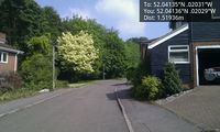
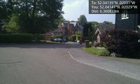
A roadside point a mile south of Royston railway station, Hertfordshire, UK.
The link from the map to the right appears to be broken and linking to the wrong hashpoint!
From Sourcerer's description I think we're going for (52.041354154131255, -0.02031179801003233).
carabiner.peeron.com/xkcd/map/map.html is broken too. It fails to retrieve the DOW.
Participants
- Sourcerer
- Tongs/B but not the other Tongs, who are away for the weekend.
Plans
Visit at 4pm unless we agree a different time on the discussion page. I'll bring my 2 metre rig and listen on 145.5 MHz.
Expedition
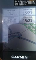
Sourcerer set out by car at 13:30 expecting a two hour journey avoiding the popular air show at Duxford. The traffic was surprisingly light for a bank holiday long weekend. The evidence photo was snapped at 15:21. Both Sourcerer and Tongs/B are licensed radio amateurs and we were able to talk by radio on 145.5 MHz as Tongs/B made his approach 15 minutes later. We then sat on a grassy bank beside the hashpoint and chatted for a while giving time for anyone else to show up, No one else did though. We fear the hobby is dieing out. User:Randall needs to do another cartoon!
Tongs/B
It struck me just how long it had been since I last went geohashing (nearly two years) when I got out the old GPS receiver and tried to enter the coordinates. I still check them every day but now I'm down in the Big Smoke, they aren't quite all leading to arresting serendipitous fenland vistas any more. Bah, London, eh?
However, with a bit of luck, now and then, I can jump on a train from Kings Cross and head back up there, and today the hashpoint was ideally located for this, not 2km from Royston station, itself just over half an hour from Kings Cross, and a mere £11 from my local station.
I arrived at Royston and, without batteries for the GPS, I asked Google to guide me. Twenty minutes later I got warning that Sourcerer would be on the VHF calling channel. I turned on my radio and there he was. I'm no good at remembering callsigns but I'm required to by the terms of the licence, at least for a few seconds so I can direct my message to whoever is listening. My latest one, rather a mouthful, had been allocated days ago, and yes I did trip over it a little, but we had a proper little conversation (we say 'QSO', don't you know) in which I was guided by Sourcerer to the residential street in which he was standing. Minutes later, a bearded gentleman, recognisable as the geohashing legend Sourcerer, could be seen.
Being forty minutes early, we sat on the grassy bank and caught up on all that had happened since two years ago. Over an hour flew past and it was time to say goodbye until next year.
Tongs/B went for a walk for a few hours on Therfield Heath, exploring its lovely woods. At the top of the hill, he realised the valley opening up before him contained a couple of the repeaters he first used after being licensed, connected to GB3PI, and chatted to a friend from back there. It was then a short walk back to the station and home.
Photos
- Gallery
Arrived. @52.0414,-.0203
HP. @52.0414,-.0203
HP. @52.0414,-.0203

Sourcerer. @52.0414,-.0204

Tongs. @52.0414,-.0203


(Tongs/B) will add photos soon.
Achievements
Sourcerer and Tongs earned the 2018 Mouse Over Day achievement
|
Expeditions and Plans
| 2018-05-26 | ||
|---|---|---|
| Johannesburg (East), South Africa | Theblazehen | On the golf course at the campus |
| Hamilton, New Zealand | Krintar | Somewhere |
| Gastonia, North Carolina | OtherJack | Woods near a golf course in Tega Cay, near Lake Wylie. |
| Northampton, United Kingdom | Sourcerer, Tongs/B | A roadside point a mile south of Royston railway station, Hertfordshire, UK... |
| Cambridge, United Kingdom | Someone went | An arable field close to the meridian. 2018-05-26 52 -0 is much more convenient, one mile s... |
Sourcerer's Expedition Links
2018-05-21_52_1 - 2018-05-26_52_-0 - 2018-05-31_52_-0 - KML file download of Sourcerer's expeditions for use with Google Earth.