Difference between revisions of "2019-01-12 51 8"
From Geohashing
imported>GeorgDerReisende (planning an expedition) |
imported>FippeBot m (Location) |
||
| (2 intermediate revisions by one other user not shown) | |||
| Line 1: | Line 1: | ||
| − | |||
| − | |||
| − | |||
| − | |||
| − | |||
| − | |||
| − | |||
| − | |||
| − | |||
| − | |||
{{meetup graticule | {{meetup graticule | ||
| lat=51 | | lat=51 | ||
| Line 19: | Line 9: | ||
== Location == | == Location == | ||
| − | + | ||
| + | Between the Detmolder Straße and Löllmannshof in Bielefeld, if Bielefeld exists. | ||
== Participants == | == Participants == | ||
| − | + | ||
| − | + | [[User:GeorgDerReisende|GeorgDerReisende]] | |
== Plans == | == Plans == | ||
| − | + | ||
| + | Using public transport like trams, buses and trains. Arriving at hash o'clock. | ||
== Expedition == | == Expedition == | ||
| − | |||
| − | + | I took two trams, two trains, and a bus and arrived at 15:34 at the bus stop Löllmannshof, about 80 meters near to the hash. The hash lay on some grass near the Detmolder Straße. | |
| − | |||
== Photos == | == Photos == | ||
| − | |||
| − | |||
| − | |||
<gallery perrow="5"> | <gallery perrow="5"> | ||
| + | Image: 2019-01-12 51 8 GeorgDerReisende 4429.jpg | I arrived by bus | ||
| + | Image: 2019-01-12 51 8 GeorgDerReisende 4431.jpg | 80 meters to hash | ||
| + | Image: 2019-01-12 51 8 GeorgDerReisende 4435.jpg | some grass with a hash | ||
| + | Image: 2019-01-12 51 8 GeorgDerReisende 4438.jpg | I danced around, with the camera in hand, to get a good shot, and I got this | ||
| + | Image: 2019-01-12 51 8 GeorgDerReisende 4439.jpg | proof | ||
| + | Image: 2019-01-12 51 8 GeorgDerReisende 4440.jpg | looking north | ||
| + | Image: 2019-01-12 51 8 GeorgDerReisende 4441.jpg | east | ||
| + | Image: 2019-01-12 51 8 GeorgDerReisende 4442.jpg | south | ||
| + | Image: 2019-01-12 51 8 GeorgDerReisende 4443.jpg | west | ||
| + | Image: 2019-01-12 51 8 GeorgDerReisende 4445.jpg | a wet geohasher | ||
</gallery> | </gallery> | ||
| Line 45: | Line 42: | ||
<!-- Add any achievement ribbons you earned below, or remove this section --> | <!-- Add any achievement ribbons you earned below, or remove this section --> | ||
| − | + | {{XKCD Centurion | count = 49 | name = GeorgDerReisende }} | |
| − | |||
| − | |||
| − | + | [[Category:Expeditions]] | |
| − | + | [[Category:Expeditions with photos]] | |
| − | |||
| − | |||
| − | |||
| − | |||
| − | |||
| − | |||
| − | |||
| − | |||
| − | |||
| − | |||
| − | |||
| − | |||
| − | |||
| − | |||
| − | |||
| − | |||
[[Category:Coordinates reached]] | [[Category:Coordinates reached]] | ||
| − | + | {{location|DE|NW|BI}} | |
| − | |||
| − | |||
| − | |||
| − | |||
| − | |||
| − | |||
| − | |||
| − | |||
| − | |||
| − | |||
| − | |||
| − | |||
| − | |||
| − | |||
| − | |||
| − | |||
| − | |||
Latest revision as of 04:25, 16 August 2019
| Sat 12 Jan 2019 in 51,8: 51.9952022, 8.5964847 geohashing.info google osm bing/os kml crox |
Location
Between the Detmolder Straße and Löllmannshof in Bielefeld, if Bielefeld exists.
Participants
Plans
Using public transport like trams, buses and trains. Arriving at hash o'clock.
Expedition
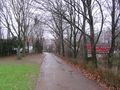
I took two trams, two trains, and a bus and arrived at 15:34 at the bus stop Löllmannshof, about 80 meters near to the hash. The hash lay on some grass near the Detmolder Straße.
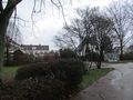
Photos
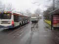
I arrived by bus
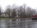
80 meters to hash
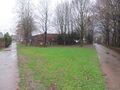
some grass with a hash
- Error creating thumbnail: Unable to save thumbnail to destination
I danced around, with the camera in hand, to get a good shot, and I got this
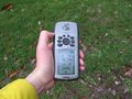
proof
looking north
east
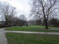
south
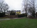
west

a wet geohasher


Achievements
GeorgDerReisende earned the xkcd Quadraginturion achievement
|