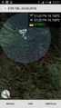
2019-03-23 51 10
| Sat 23 Mar 2019 in 51,10: 51.2213311, 10.1555120 geohashing.info google osm bing/os kml crox |
Location
In a forest east of Grosstöpfer
Participants
Plans
Drive to Grosstöpfer and do a little hike to the geohash.
Expedition
As planned, I drove to Grosstöpfer, which were some 25 kilometers / 30 minutes... I parked my car in the little town and walked all the way up to the hash from there. The first part of the tour followed the 'Eichsfeldwanderweg' - a great trail through the Eichsfeld in Thuringia. After some 15 minutes I came across a road, which I followed for another 400 meters, to get to the hash at about 70 meters close. From there, I had to crawl my way through some pretty wild forest, and somehow the longest hashdance ever had just started hehe... First, I climbed my way up some 25 meters too much to the east, so I had to get down again. But, having reached the hashpoint, it was 20 meters off again... So I climbed up a little bit again, went to the north, went to the south - carefully to not slip away... But after some 10 minutes of dancing around, I could finally spot the hash, which was actually a little hole (maybe used by foxes)! Proof was taken at once - before the coordinates would've jumped around again...
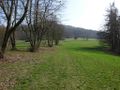
Satisfied I climbed my way back down to the road, and enjoyed some nice views on my way back to my car. After all, this was quite an easy one - under 2 kilometers in total, but also a physically demanding one - being on pretty steep terrain.
Tracklog
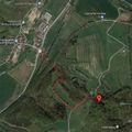
Today's track / map

Photos
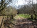
The way to the hash
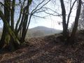
The hash was on the mountain in the background
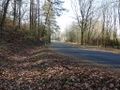
Approaching the road
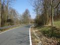
Following the road
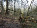
Final meters to the hash
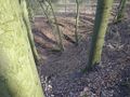
Pretty steep
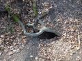
The hash was this little hole
The hash - screenshot
On my way back
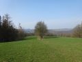
Nice view from here


