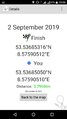
2019-09-02 53 8
| Mon 2 Sep 2019 in Bremen: 53.5368532, 8.5759051 geohashing.info google osm bing/os kml crox |
Location
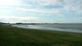
This Geohash is located on a beach in Bremerhaven.
Participants
Expedition
Day 2 of the Geohashing Wiki being offline.
From Hannover, I took the train to Bremerhaven, and walked the rest of the distance from there.
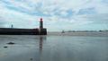
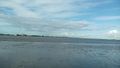
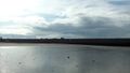
On the way to the beach I crossed the river Geeste. It is however dwarfed by the river Weser which flows into the North Sea and is at its widest here. The Geohash is on a beach which lies on the Weser.
The Weser is tidal here, which is relevant since the coordinates of this geohash sometimes are on land, and sometimes are under water. There are two low tides today, one at 10:31 and one at 22:59, a high tide at 16:23 being in-between them. I chose to be there at the first low tide and arrived at 10:00, just as the beach opened.
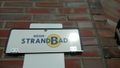
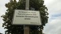
This beach, by the way, is quite peculiar since one is not allowed to swim at this beach. The signs warn that it is life-threatening since the Weser's currents are very strong. I wonder why they put a beach there in the first place then.
I found the Beach Master (or whatever the translation of Strandmeister, the person in charge of the beach, is), he was flattening the sand. I tried to pay him, but he said that he did not have his cashbox on him, and asked how long I wanted to stay, probably wondering who goes to the beach on a cold Monday morning. I responded that I would only stay for a few minutes, taking a few pictures. In that case, he said, I can just take the pictures without paying. Nice, I thought, instead of being an Admit One Geohash it is going to be an Ambassador geohash. I thanked him.
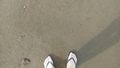
Even though it was not 10:31 yet, and the tide was not at its lowest point yet, the Geohash was already on land, although it was not dry land. I'm glad I took my flip-flops. After locating the coordinates I recorded proof and took the pictures.
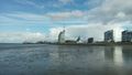
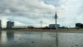
Afterwards, I left the beach and went north to visit a particular part of the harbor. You see, Bremerhaven has an interesting exclave-enclave situation. Here is a diagram. The state of Bremen does not only consist of the city of Bremen, since the state has an exclave, separated by 30km of Lower Saxony: Bremerhaven. Bremerhaven also has an exclave, a forest at 53.605,8.65, separated by a thin Lower Saxonian land strip. The city of Bremen also has an exclave, and it is located within Bremerhaven: The Stadtbremisches Überseehafengebiet, the City of Bremen's Overseas Port Area. I went to this area, but there was no yellow sign stating that one was entering the city of Bremen. However, there was a sign stating that the use of fire was forbidden, signed by an authority of the city of Bremen. I'll take it.
On the way, I saw several nice old-fashioned ships, and photographed one of them, the Seute Deern. I searched for the ship online afterwards, and was surprised to find out that it had sunk on the 30th of August, only three days before the expedition. I suppose they already pulled it back out of the water again, or the water where it is supposed to float is not very deep in the first place. Anyway, I was a bit confused about that.
From the exclave I walked back to the train station, and took the train back to Hannover.
Photos
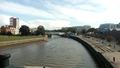
Crossing the Geeste
At the Beach
Proof
The Geohash
Surroundings
Surroundings
Surroundings
Surroundings
Surroundings
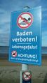
No swimming allowed
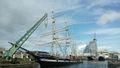
The Seute Deern
View of the Weser and the Beach, including the Geohash
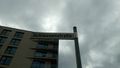
In the city of Bremen's exclave in Bremerhaven
At the border street of the exclave.


Ribbons
Fippe earned the Land geohash achievement
|
Fippe earned the Regional geohashing achievement
|
Fippe earned the Ambassador achievement
|