Difference between revisions of "2020-01-25 48 11"
From Geohashing
(Dark Ages achievement) |
m |
||
| Line 25: | Line 25: | ||
{{Dark Ages|date=2020-01-25|latitude=48|longitude=11|name=[[User:Clearlucid9|Clearlucid9]]}} | {{Dark Ages|date=2020-01-25|latitude=48|longitude=11|name=[[User:Clearlucid9|Clearlucid9]]}} | ||
| + | [[Category:Expeditions]] | ||
| + | [[Category:Expeditions with photos]] | ||
| + | [[Category:Coordinates reached]] | ||
{{location|DE|BY|M}} | {{location|DE|BY|M}} | ||
Latest revision as of 10:33, 24 September 2021
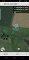
| Sat 25 Jan 2020 in Munich: 48.0596007, 11.7625158 geohashing.info google osm bing/os kml crox |
Location
on the fringe of the Harthausen golf course
Participants
Expedition
The Geohashing website was still down, but as the app kept showing the coordinates I decided to go for this one on an early Saturday morning. As the area looked to be reasonable flat I took my new drone with me (thanks Santa Clause!) to take some areal shots. It was still quite chilly and as the drone connects to my phone I had to take of my gloves off in order to use the app. After about 15 minutes I didn't feel my fingers any more and decided to drive back home and have breakfast.
Photos
logproof

me at the hash
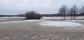
looking east
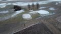
drone fiew of the area


Ribbons

Clearlucid9 earned the Dark Ages achievement
by going on an expedition to the (48, 11) geohash on 2020-01-25.